Bristol elevation
Bristol (England, City of Bristol), United Kingdom elevation is 21 meters and Bristol elevation in feet is 69 ft above sea level [src 1]. Bristol is a seat of a second-order administrative division (feature code) with elevation that is 51 meters (167 ft) smaller than average city elevation in United Kingdom.
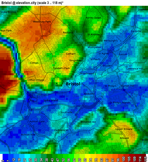
Below is the Elevation map of Bristol, which displays elevation range with different colors. Scale of the first map is from 3 to 118 m (10 to 387 ft) with average elevation of 39.5 meters (=130 ft) [note 1]
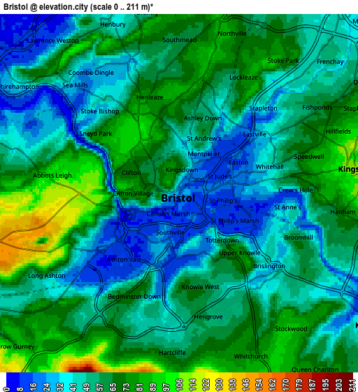
These maps also provides idea of topography and contour of this city, they are displayed at different zoom levels. More info about maps, scale and edge coordinates you can find below images.
| \ | Map #1 | Map #2 | Topo.Map |
| Scale [m] | 3..118 m | 0..211 m | × |
| Scale [ft] | 10..387 ft | 0..692 ft | × |
| Average | 39.5 m = 130 ft | 57 m = 187 ft | × |
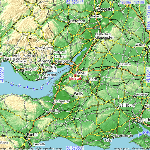
| Width | 6.09 km = 3.8 mi | 12.18 km = 7.6 mi | 194.9 km = 121.1 mi |
| Height | 6.09 km = 3.8 mi | 12.18 km = 7.6 mi | 194.9 km = 121.1 mi |
| ↑Max Latitude | 51.482605° | 51.509964° | 52.32311° |
| Latitude at center | 51.45523° | 51.45523° | 51.45523° |
| ↓Min Latitude | 51.427838° | 51.40043° | 50.57053° |
| ← Min Longitude | -2.640595° | -2.684541° | -4.0029° |
| Longitude center | -2.59665° | -2.59665° | -2.59665° |
| →Max Longitude | -2.552705° | -2.508759° | -1.1904° |
Nearby cities:
Cities around Bristol sort by population:
• Kingswood elevation 104 m
6.1 km,  92°
92°
• Mangotsfield 74 m
7.4 km,  60°
60°
• Keynsham 25 m
8.3 km,  123°
123°
• Stoke Gifford 65 m
7.9 km,  29°
29°
• Bishopsworth 52 m
4.8 km,  200°
200°
• Long Ashton 56 m
5.3 km,  237°
237°
• Easton-in-Gordano 23 m
7.5 km,  287°
287°
• Winford 107 m
9.2 km,  209°
209°
• Dundry 219 m
6.9 km, 205°
• Stanton Drew 38 m
9.8 km,  175°
175°
• Publow 49 m
9.3 km,  156°
156°
• Whitchurch 77 m
6 km, 156°
Multilingual:
 En español:
Brístol elevación 21 m.
 En France:
Bristol élévation 21 m.


Sources and notes:
- [note 1] Map square and city borders are not equal. Map elevation data is calculated only from area inside that square.
- [src 1] Elevation data from geonames database provided with same terms of usage.
- [src 2] The elevation map of Bristol is generated using elevation data from NASA's 3 arcsec (90m) resolution SRTM data.
- [src 3] Base (background) map © OpenStreetMap contributors tiles are generated by Geofabrik and OpenTopoMap.
Copyright & License:
This Bristol Elevation Map is licensed under CC BY-SA. You may reuse any part from this page, if you give a proper credit by linking to this URL:
 More info on terms of use page.