Kingswood elevation
Kingswood (England, South Gloucestershire), United Kingdom elevation is 104 meters and Kingswood elevation in feet is 341 ft above sea level [src 1]. Kingswood is a populated place (feature code) with elevation that is 32 meters (105 ft) bigger than average city elevation in United Kingdom.
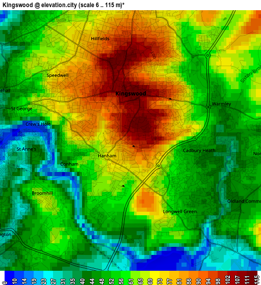
Below is the Elevation map of Kingswood, which displays elevation range with different colors. Scale of the first map is from 6 to 115 m (20 to 377 ft) with average elevation of 58.5 meters (=192 ft) [note 1]
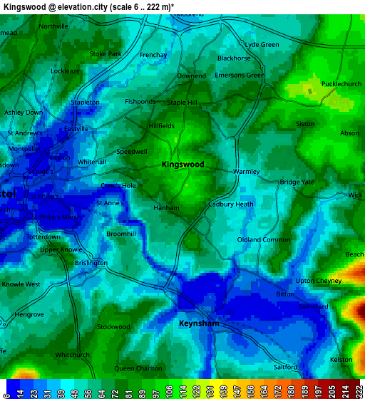
These maps also provides idea of topography and contour of this city, they are displayed at different zoom levels. More info about maps, scale and edge coordinates you can find below images.
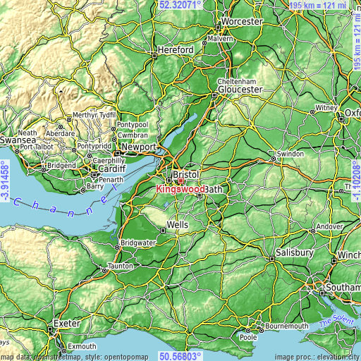
| \ | Map #1 | Map #2 | Topo.Map |
| Scale [m] | 6..115 m | 6..222 m | × |
| Scale [ft] | 20..377 ft | 20..728 ft | × |
| Average | 58.5 m = 192 ft | 58.8 m = 193 ft | × |
| Width | 6.09 km = 3.8 mi | 12.18 km = 7.6 mi | 194.9 km = 121.1 mi |
| Height | 6.09 km = 3.8 mi | 12.18 km = 7.6 mi | 194.9 km = 121.1 mi |
| ↑Max Latitude | 51.480157° | 51.507517° | 52.32071° |
| Latitude at center | 51.45278° | 51.45278° | 51.45278° |
| ↓Min Latitude | 51.425387° | 51.397977° | 50.56803° |
| ← Min Longitude | -2.552275° | -2.596221° | -3.91458° |
| Longitude center | -2.50833° | -2.50833° | -2.50833° |
| →Max Longitude | -2.464385° | -2.420439° | -1.10208° |
Nearby cities:
Cities around Kingswood sort by population:
• Bristol elevation 21 m
6.1 km,  272°
272°
• Mangotsfield 74 m
3.9 km,  4°
4°
• Keynsham 25 m
4.4 km,  170°
170°
• Stoke Gifford 65 m
7.5 km,  342°
342°
• Saltford 44 m
6.6 km,  149°
149°
• Pucklechurch 113 m
6.3 km,  54°
54°
• Wick 74 m
5.9 km,  89°
89°
• Bitton 19 m
4.6 km,  132°
132°
• Compton Dando 28 m
8.2 km,  182°
182°
• Winterbourne 70 m
7.8 km, 2°
• Whitchurch 77 m
6.4 km,  215°
215°
• Siston 79 m
4.7 km,  59°
59°
Multilingual:
 En español:
Kingswood elevación 104 m.
 En France:
Kingswood élévation 104 m.
 Auf Deutsch:
Kingswood höhe über dem Meeresspiegel ist 104 m.

Sources and notes:
- [note 1] Map square and city borders are not equal. Map elevation data is calculated only from area inside that square.
- [src 1] Elevation data from geonames database provided with same terms of usage.
- [src 2] The elevation map of Kingswood is generated using elevation data from NASA's 3 arcsec (90m) resolution SRTM data.
- [src 3] Base (background) map © OpenStreetMap contributors tiles are generated by Geofabrik and OpenTopoMap.
Copyright & License:
This Kingswood Elevation Map is licensed under CC BY-SA. You may reuse any part from this page, if you give a proper credit by linking to this URL:
 More info on terms of use page.