Brockhampton elevation
Brockhampton (England, Herefordshire), United Kingdom elevation is 97 meters and Brockhampton elevation in feet is 318 ft above sea level [src 1]. Brockhampton is a seat of a third-order administrative division (feature code) with elevation that is 25 meters (82 ft) bigger than average city elevation in United Kingdom.
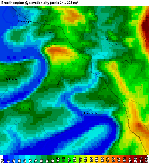
Below is the Elevation map of Brockhampton, which displays elevation range with different colors. Scale of the first map is from 34 to 223 m (112 to 732 ft) with average elevation of 90.8 meters (=298 ft) [note 1]
These maps also provides idea of topography and contour of this city, they are displayed at different zoom levels. More info about maps, scale and edge coordinates you can find below images.
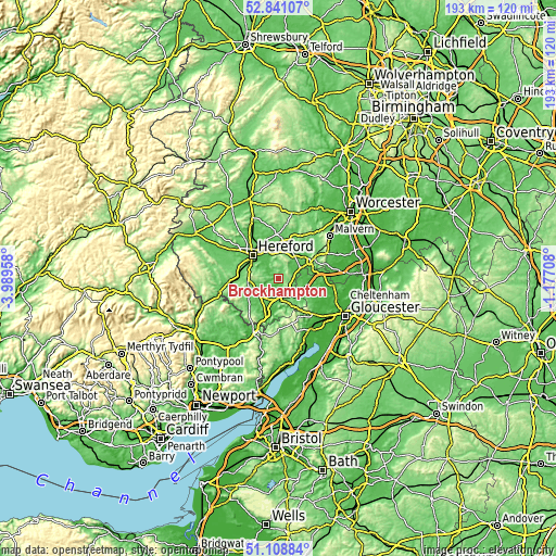
| \ | Map #1 | Topo.Map |
| Scale [m] | 34..223 m | × |
| Scale [ft] | 112..732 ft | × |
| Average | 90.8 m = 298 ft | × |
| Width | 6.02 km = 3.7 mi | 192.6 km = 119.7 mi |
| Height | 6.02 km = 3.7 mi | 192.6 km = 119.7 mi |
| ↑Max Latitude | 52.010387° | 52.84107° |
| Latitude at center | 51.98333° | 51.98333° |
| ↓Min Latitude | 51.956256° | 51.10884° |
| ← Min Longitude | -2.627275° | -3.98958° |
| Longitude center | -2.58333° | -2.58333° |
| →Max Longitude | -2.539385° | -1.17708° |
Nearby cities:
Cities around Brockhampton sort by population:
• Ross on Wye elevation 39 m
7.5 km,  171°
171°
• Lugwardine 71 m
10.5 km,  330°
330°
• Donnington 60 m
11.6 km,  80°
80°
• Walford 35 m
11.2 km,  185°
185°
• Callow 77 m
10.9 km,  289°
289°
• Lea 112 m
10.9 km,  148°
148°
• Lower Bullingham 56 m
9.7 km,  304°
304°
• Much Birch 163 m
9.7 km,  261°
261°
• Pencoyd 108 m
9.7 km,  235°
235°
• Linton 110 m
8.8 km,  137°
137°
• Sellack 38 m
5 km,  222°
222°
• Yatton 134 m
3.9 km,  118°
118°
Multilingual:
 En español:
Brockhampton elevación 97 m.
 En France:
Brockhampton élévation 97 m.
 Auf Deutsch:
Brockhampton höhe über dem Meeresspiegel ist 97 m.

Sources and notes:
- [note 1] Map square and city borders are not equal. Map elevation data is calculated only from area inside that square.
- [src 1] Elevation data from geonames database provided with same terms of usage.
- [src 2] The elevation map of Brockhampton is generated using elevation data from NASA's 3 arcsec (90m) resolution SRTM data.
- [src 3] Base (background) map © OpenStreetMap contributors tiles are generated by Geofabrik and OpenTopoMap.
Copyright & License:
This Brockhampton Elevation Map is licensed under CC BY-SA. You may reuse any part from this page, if you give a proper credit by linking to this URL:
 More info on terms of use page.