Donnington elevation
Donnington (England, Herefordshire), United Kingdom elevation is 60 meters and Donnington elevation in feet is 197 ft above sea level [src 1]. Donnington is a seat of a third-order administrative division (feature code) with elevation that is 12 meters (39 ft) smaller than average city elevation in United Kingdom.
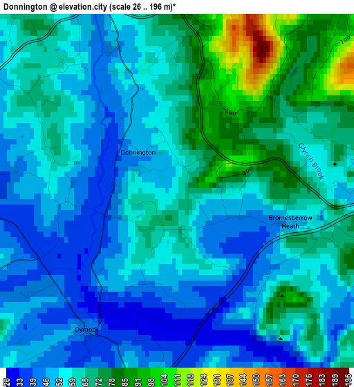
Below is the Elevation map of Donnington, which displays elevation range with different colors. Scale of the first map is from 26 to 196 m (85 to 643 ft) with average elevation of 59.5 meters (=195 ft) [note 1]
These maps also provides idea of topography and contour of this city, they are displayed at different zoom levels. More info about maps, scale and edge coordinates you can find below images.
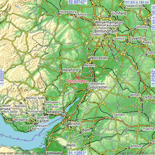
| \ | Map #1 | Topo.Map |
| Scale [m] | 26..196 m | × |
| Scale [ft] | 85..643 ft | × |
| Average | 59.5 m = 195 ft | × |
| Width | 6.02 km = 3.7 mi | 192.5 km = 119.6 mi |
| Height | 6.02 km = 3.7 mi | 192.5 km = 119.6 mi |
| ↑Max Latitude | 52.027047° | 52.85742° |
| Latitude at center | 52° | 52° |
| ↓Min Latitude | 51.972936° | 51.12583° |
| ← Min Longitude | -2.460615° | -3.82292° |
| Longitude center | -2.41667° | -2.41667° |
| →Max Longitude | -2.372725° | -1.01042° |
Nearby cities:
Cities around Donnington sort by population:
• Great Malvern elevation 118 m
13.9 km,  26°
26°
• Ross on Wye 39 m
13.8 km,  227°
227°
• Ledbury 67 m
4.1 km,  350°
350°
• Newent 41 m
7.4 km,  175°
175°
• Corse 27 m
8.8 km,  120°
120°
• Huntley 53 m
14.3 km, 175°
• Longhope 72 m
15 km,  188°
188°
• Evesbatch 146 m
15 km, 351°
• Lea 112 m
12.5 km,  207°
207°
• Brockhampton 97 m
11.6 km,  260°
260°
• Linton 110 m
10 km, 213°
• Yatton 134 m
8.8 km,  245°
245°
Multilingual:
 En español:
Donnington elevación 60 m.
 En France:
Donnington élévation 60 m.
 Auf Deutsch:
Donnington höhe über dem Meeresspiegel ist 60 m.

Sources and notes:
- [note 1] Map square and city borders are not equal. Map elevation data is calculated only from area inside that square.
- [src 1] Elevation data from geonames database provided with same terms of usage.
- [src 2] The elevation map of Donnington is generated using elevation data from NASA's 3 arcsec (90m) resolution SRTM data.
- [src 3] Base (background) map © OpenStreetMap contributors tiles are generated by Geofabrik and OpenTopoMap.
Copyright & License:
This Donnington Elevation Map is licensed under CC BY-SA. You may reuse any part from this page, if you give a proper credit by linking to this URL:
 More info on terms of use page.