Lugwardine elevation
Lugwardine (England, Herefordshire), United Kingdom elevation is 71 meters and Lugwardine elevation in feet is 233 ft above sea level [src 1]. Lugwardine is a populated place (feature code) with elevation that is 1 meters (3 ft) smaller than average city elevation in United Kingdom.
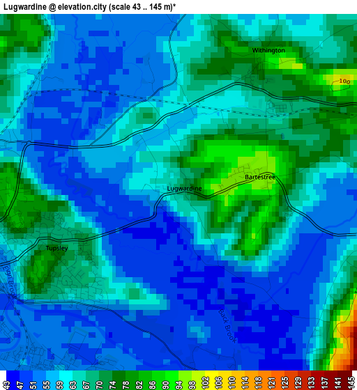
Below is the Elevation map of Lugwardine, which displays elevation range with different colors. Scale of the first map is from 43 to 145 m (141 to 476 ft) with average elevation of 61.7 meters (=202 ft) [note 1]
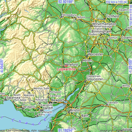
These maps also provides idea of topography and contour of this city, they are displayed at different zoom levels. More info about maps, scale and edge coordinates you can find below images.
| \ | Map #1 | Topo.Map |
| Scale [m] | 43..145 m | × |
| Scale [ft] | 141..476 ft | × |
| Average | 61.7 m = 202 ft | × |
| Width | 6.01 km = 3.7 mi | 192.3 km = 119.5 mi |
| Height | 6.01 km = 3.7 mi | 192.2 km = 119.4 mi |
| ↑Max Latitude | 52.092837° | 52.92198° |
| Latitude at center | 52.06583° | 52.06583° |
| ↓Min Latitude | 52.038806° | 51.19294° |
| ← Min Longitude | -2.701745° | -4.06405° |
| Longitude center | -2.6578° | -2.6578° |
| →Max Longitude | -2.613855° | -1.25155° |
Nearby cities:
Cities around Lugwardine sort by population:
• Hereford elevation 61 m
4 km,  255°
255°
• Belmont 63 m
6.3 km,  245°
245°
• Credenhill 76 m
10.5 km,  280°
280°
• Brockhampton 97 m
10.5 km,  150°
150°
• Bodenham 60 m
9.5 km,  349°
349°
• Moreton Jeffries 98 m
9.4 km,  34°
34°
• Wellington 64 m
9.1 km,  320°
320°
• Callow 77 m
7.5 km,  223°
223°
• Ocle Pychard 80 m
6.9 km, 34°
• Lower Bullingham 56 m
4.6 km, 218°
• Sutton 52 m
4.2 km,  335°
335°
• Withington 72 m
4.2 km,  23°
23°
Multilingual:
 En español:
Lugwardine elevación 71 m.
 En France:
Lugwardine élévation 71 m.
 Auf Deutsch:
Lugwardine höhe über dem Meeresspiegel ist 71 m.

Sources and notes:
- [note 1] Map square and city borders are not equal. Map elevation data is calculated only from area inside that square.
- [src 1] Elevation data from geonames database provided with same terms of usage.
- [src 2] The elevation map of Lugwardine is generated using elevation data from NASA's 3 arcsec (90m) resolution SRTM data.
- [src 3] Base (background) map © OpenStreetMap contributors tiles are generated by Geofabrik and OpenTopoMap.
Copyright & License:
This Lugwardine Elevation Map is licensed under CC BY-SA. You may reuse any part from this page, if you give a proper credit by linking to this URL:
 More info on terms of use page.