Carnwath elevation
Carnwath (Scotland, South Lanarkshire), United Kingdom elevation is 218 meters and Carnwath elevation in feet is 715 ft above sea level [src 1]. Carnwath is a populated place (feature code) with elevation that is 146 meters (479 ft) bigger than average city elevation in United Kingdom.
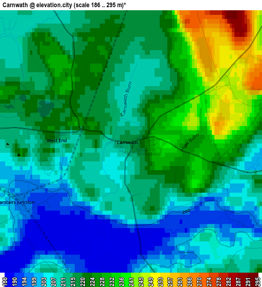
Below is the Elevation map of Carnwath, which displays elevation range with different colors. Scale of the first map is from 186 to 295 m (610 to 968 ft) with average elevation of 216.3 meters (=710 ft) [note 1]
These maps also provides idea of topography and contour of this city, they are displayed at different zoom levels. More info about maps, scale and edge coordinates you can find below images.
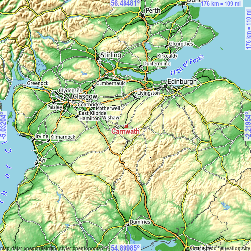
| \ | Map #1 | Topo.Map |
| Scale [m] | 186..295 m | × |
| Scale [ft] | 610..968 ft | × |
| Average | 216.3 m = 710 ft | × |
| Width | 5.51 km = 3.4 mi | 176.2 km = 109.5 mi |
| Height | 5.51 km = 3.4 mi | 176.2 km = 109.5 mi |
| ↑Max Latitude | 55.725116° | 56.48481° |
| Latitude at center | 55.70036° | 55.70036° |
| ↓Min Latitude | 55.675588° | 54.89985° |
| ← Min Longitude | -3.669735° | -5.03204° |
| Longitude center | -3.62579° | -3.62579° |
| →Max Longitude | -3.581845° | -2.21954° |
Nearby cities:
Cities around Carnwath sort by population:
• Carluke elevation 210 m
13.4 km,  287°
287°
• Lanark 199 m
10.2 km,  253°
253°
• Shotts 216 m
17.1 km,  320°
320°
• Fauldhouse 230 m
15 km,  340°
340°
• Law 170 m
17 km, 288°
• West Calder 177 m
17.2 km,  11°
11°
• Biggar 215 m
10.7 km,  143°
143°
• Forth 281 m
8.2 km,  331°
331°
• Stoneyburn 189 m
16 km,  357°
357°
• West Linton 235 m
17.8 km,  71°
71°
• Addiebrownhill 198 m
15.9 km,  2°
2°
• Allanton 183 m
17.1 km,  310°
310°
Multilingual:
 En español:
Carnwath elevación 218 m.
 En France:
Carnwath élévation 218 m.
 Auf Deutsch:
Carnwath höhe über dem Meeresspiegel ist 218 m.

Sources and notes:
- [note 1] Map square and city borders are not equal. Map elevation data is calculated only from area inside that square.
- [src 1] Elevation data from geonames database provided with same terms of usage.
- [src 2] The elevation map of Carnwath is generated using elevation data from NASA's 3 arcsec (90m) resolution SRTM data.
- [src 3] Base (background) map © OpenStreetMap contributors tiles are generated by Geofabrik and OpenTopoMap.
Copyright & License:
This Carnwath Elevation Map is licensed under CC BY-SA. You may reuse any part from this page, if you give a proper credit by linking to this URL:
 More info on terms of use page.