Biggar elevation
Biggar (Scotland, South Lanarkshire), United Kingdom elevation is 215 meters and Biggar elevation in feet is 705 ft above sea level [src 1]. Biggar is a populated place (feature code) with elevation that is 143 meters (469 ft) bigger than average city elevation in United Kingdom.
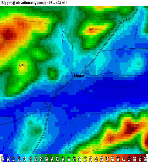
Below is the Elevation map of Biggar, which displays elevation range with different colors. Scale of the first map is from 195 to 403 m (640 to 1322 ft) with average elevation of 246.3 meters (=808 ft) [note 1]
These maps also provides idea of topography and contour of this city, they are displayed at different zoom levels. More info about maps, scale and edge coordinates you can find below images.
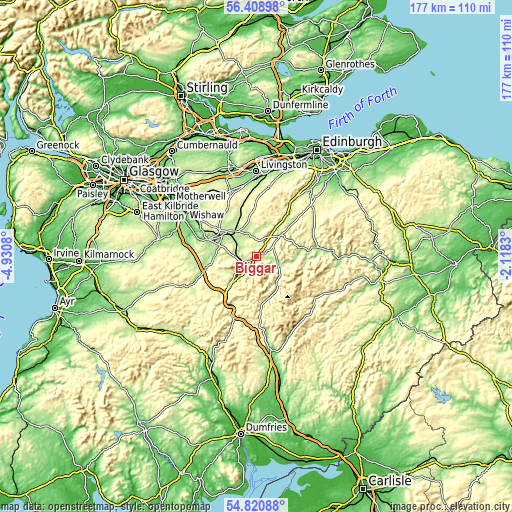
| \ | Map #1 | Topo.Map |
| Scale [m] | 195..403 m | × |
| Scale [ft] | 640..1322 ft | × |
| Average | 246.3 m = 808 ft | × |
| Width | 5.52 km = 3.4 mi | 176.6 km = 109.7 mi |
| Height | 5.52 km = 3.4 mi | 176.6 km = 109.7 mi |
| ↑Max Latitude | 55.647775° | 56.40898° |
| Latitude at center | 55.62297° | 55.62297° |
| ↓Min Latitude | 55.598149° | 54.82088° |
| ← Min Longitude | -3.568495° | -4.9308° |
| Longitude center | -3.52455° | -3.52455° |
| →Max Longitude | -3.480605° | -2.1183° |
Nearby cities:
Cities around Biggar sort by population:
• Carluke elevation 210 m
22.9 km,  303°
303°
• Lanark 199 m
17.1 km,  289°
289°
• Peebles 170 m
21.3 km,  81°
81°
• Fauldhouse 230 m
25.5 km,  333°
333°
• Lesmahagow 176 m
22.8 km,  273°
273°
• Forth 281 m
18.9 km, 326°
• Blackwood 175 m
25.1 km,  281°
281°
• Douglas 206 m
22 km,  248°
248°
• West Linton 235 m
17.6 km,  36°
36°
• Addiebrownhill 198 m
25.1 km,  346°
346°
• Carnwath 218 m
10.7 km,  323°
323°
• Coalburn 236 m
23 km,  261°
261°
Multilingual:
 En español:
Biggar elevación 215 m.
 En France:
Biggar élévation 215 m.


Sources and notes:
- [note 1] Map square and city borders are not equal. Map elevation data is calculated only from area inside that square.
- [src 1] Elevation data from geonames database provided with same terms of usage.
- [src 2] The elevation map of Biggar is generated using elevation data from NASA's 3 arcsec (90m) resolution SRTM data.
- [src 3] Base (background) map © OpenStreetMap contributors tiles are generated by Geofabrik and OpenTopoMap.
Copyright & License:
This Biggar Elevation Map is licensed under CC BY-SA. You may reuse any part from this page, if you give a proper credit by linking to this URL:
 More info on terms of use page.