Chard elevation
Chard (England, Somerset), United Kingdom elevation is 118 meters and Chard elevation in feet is 387 ft above sea level [src 1]. Chard is a populated place (feature code) with elevation that is 46 meters (151 ft) bigger than average city elevation in United Kingdom.
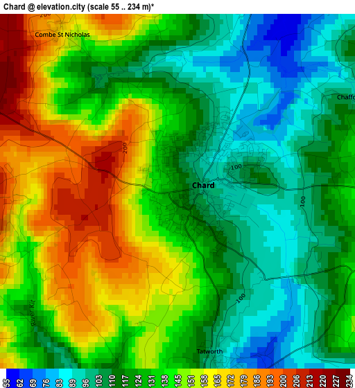
Below is the Elevation map of Chard, which displays elevation range with different colors. Scale of the first map is from 55 to 234 m (180 to 768 ft) with average elevation of 131.8 meters (=432 ft) [note 1]
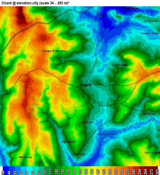
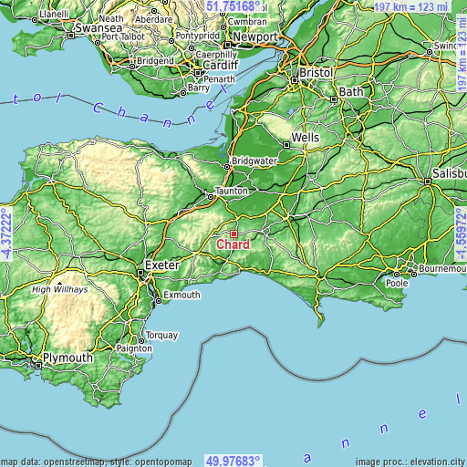
These maps also provides idea of topography and contour of this city, they are displayed at different zoom levels. More info about maps, scale and edge coordinates you can find below images.
| \ | Map #1 | Map #2 | Topo.Map |
| Scale [m] | 55..234 m | 34..283 m | × |
| Scale [ft] | 180..768 ft | 112..928 ft | × |
| Average | 131.8 m = 432 ft | 134.6 m = 442 ft | × |
| Width | 6.17 km = 3.8 mi | 12.33 km = 7.7 mi | 197.3 km = 122.6 mi |
| Height | 6.17 km = 3.8 mi | 12.33 km = 7.7 mi | 197.3 km = 122.6 mi |
| ↑Max Latitude | 50.900423° | 50.92813° | 51.75168° |
| Latitude at center | 50.8727° | 50.8727° | 50.8727° |
| ↓Min Latitude | 50.84496° | 50.817204° | 49.97683° |
| ← Min Longitude | -3.009915° | -3.053861° | -4.37222° |
| Longitude center | -2.96597° | -2.96597° | -2.96597° |
| →Max Longitude | -2.922025° | -2.878079° | -1.55972° |
Nearby cities:
Cities around Chard sort by population:
• Honiton elevation 113 m
17.6 km,  242°
242°
• Crewkerne 74 m
12 km,  84°
84°
• Ilminster 47 m
7.2 km,  33°
33°
• Axminster 44 m
10.3 km,  192°
192°
• Lyme Regis 15 m
16.4 km,  172°
172°
• South Petherton 41 m
14 km,  52°
52°
• Beaminster 58 m
17.4 km,  113°
113°
• Colyton 29 m
16.5 km,  206°
206°
• Stoke-sub-Hamdon 53 m
17.6 km,  59°
59°
• Merriott 59 m
12.8 km,  69°
69°
• Creech Saint Michael 11 m
17.5 km,  343°
343°
• Charmouth 18 m
15.6 km,  162°
162°
Multilingual:
 En español:
Chard elevación 118 m.
 En France:
Chard élévation 118 m.


Sources and notes:
- [note 1] Map square and city borders are not equal. Map elevation data is calculated only from area inside that square.
- [src 1] Elevation data from geonames database provided with same terms of usage.
- [src 2] The elevation map of Chard is generated using elevation data from NASA's 3 arcsec (90m) resolution SRTM data.
- [src 3] Base (background) map © OpenStreetMap contributors tiles are generated by Geofabrik and OpenTopoMap.
Copyright & License:
This Chard Elevation Map is licensed under CC BY-SA. You may reuse any part from this page, if you give a proper credit by linking to this URL:
 More info on terms of use page.