Honiton elevation
Honiton (England, Devon), United Kingdom elevation is 113 meters and Honiton elevation in feet is 371 ft above sea level [src 1]. Honiton is a populated place (feature code) with elevation that is 41 meters (135 ft) bigger than average city elevation in United Kingdom.
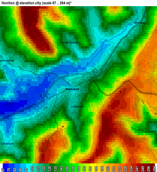
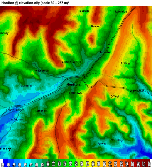
Below is the Elevation map of Honiton, which displays elevation range with different colors. Scale of the first map is from 67 to 264 m (220 to 866 ft) with average elevation of 154.7 meters (=508 ft) [note 1]
These maps also provides idea of topography and contour of this city, they are displayed at different zoom levels. More info about maps, scale and edge coordinates you can find below images.
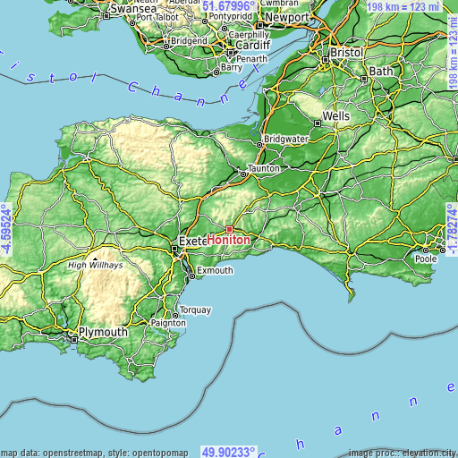
| \ | Map #1 | Map #2 | Topo.Map |
| Scale [m] | 67..264 m | 30..287 m | × |
| Scale [ft] | 220..866 ft | 98..942 ft | × |
| Average | 154.7 m = 508 ft | 161.4 m = 530 ft | × |
| Width | 6.18 km = 3.8 mi | 12.35 km = 7.7 mi | 197.7 km = 122.8 mi |
| Height | 6.18 km = 3.8 mi | 12.35 km = 7.7 mi | 197.6 km = 122.8 mi |
| ↑Max Latitude | 50.827367° | 50.855117° | 51.67996° |
| Latitude at center | 50.7996° | 50.7996° | 50.7996° |
| ↓Min Latitude | 50.771817° | 50.744017° | 49.90233° |
| ← Min Longitude | -3.232935° | -3.276881° | -4.59524° |
| Longitude center | -3.18899° | -3.18899° | -3.18899° |
| →Max Longitude | -3.145045° | -3.101099° | -1.78274° |
Nearby cities:
Cities around Honiton sort by population:
• Sidmouth elevation 40 m
12.6 km,  196°
196°
• Cullompton 59 m
15.6 km,  293°
293°
• Axminster 44 m
13.6 km,  98°
98°
• Ottery St Mary 81 m
7.8 km,  224°
224°
• Willand 63 m
15.6 km,  306°
306°
• Colyton 29 m
10.7 km,  128°
128°
• Uffculme 92 m
15.3 km,  320°
320°
• Bradninch 75 m
16.8 km,  279°
279°
• Newton Poppleford 37 m
13.4 km,  214°
214°
• Hemyock 140 m
12.8 km,  347°
347°
• Dunkeswell 238 m
7.4 km,  341°
341°
• Whimple 51 m
12.3 km,  252°
252°
Multilingual:
 En español:
Honiton elevación 113 m.
 En France:
Honiton élévation 113 m.


Sources and notes:
- [note 1] Map square and city borders are not equal. Map elevation data is calculated only from area inside that square.
- [src 1] Elevation data from geonames database provided with same terms of usage.
- [src 2] The elevation map of Honiton is generated using elevation data from NASA's 3 arcsec (90m) resolution SRTM data.
- [src 3] Base (background) map © OpenStreetMap contributors tiles are generated by Geofabrik and OpenTopoMap.
Copyright & License:
This Honiton Elevation Map is licensed under CC BY-SA. You may reuse any part from this page, if you give a proper credit by linking to this URL:
 More info on terms of use page.