Cray elevation
Cray (Wales, Sir Powys), United Kingdom elevation is 309 meters and Cray elevation in feet is 1014 ft above sea level [src 1]. Cray is a seat of a third-order administrative division (feature code) with elevation that is 237 meters (778 ft) bigger than average city elevation in United Kingdom.
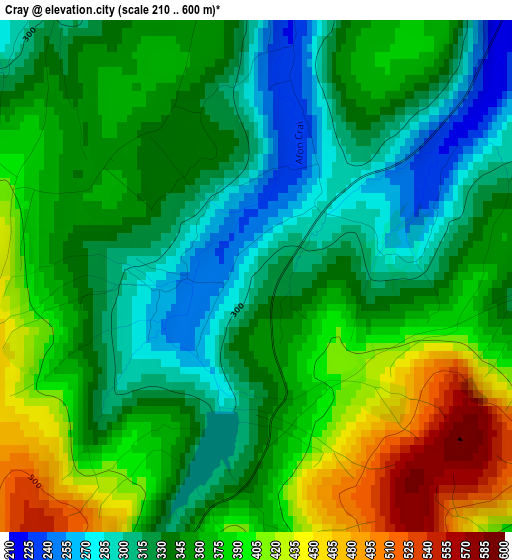
Below is the Elevation map of Cray, which displays elevation range with different colors. Scale of the first map is from 210 to 600 m (689 to 1969 ft) with average elevation of 356.8 meters (=1171 ft) [note 1]
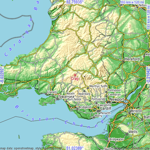
These maps also provides idea of topography and contour of this city, they are displayed at different zoom levels. More info about maps, scale and edge coordinates you can find below images.
| \ | Map #1 | Topo.Map |
| Scale [m] | 210..600 m | × |
| Scale [ft] | 689..1969 ft | × |
| Average | 356.8 m = 1171 ft | × |
| Width | 6.03 km = 3.7 mi | 193 km = 119.9 mi |
| Height | 6.03 km = 3.7 mi | 192.9 km = 119.9 mi |
| ↑Max Latitude | 51.927108° | 52.75935° |
| Latitude at center | 51.9° | 51.9° |
| ↓Min Latitude | 51.872876° | 51.02389° |
| ← Min Longitude | -3.660615° | -5.02292° |
| Longitude center | -3.61667° | -3.61667° |
| →Max Longitude | -3.572725° | -2.21042° |
Nearby cities:
Cities around Cray sort by population:
• Ystalyfera elevation 74 m
18.6 km,  217°
217°
• Brecon 136 m
16.4 km,  71°
71°
• Hirwaun 189 m
19.3 km,  157°
157°
• Brynamman 214 m
20.5 km,  237°
237°
• Glyn-neath 62 m
17 km,  180°
180°
• Seven Sisters 166 m
16.3 km,  204°
204°
• Resolven 28 m
21.6 km,  194°
194°
• Llandovery 68 m
16.2 km,  310°
310°
• Crynant 112 m
21.1 km,  205°
205°
• Llansadwrn 54 m
20.2 km,  285°
285°
• Ystradgynlais 68 m
18.1 km, 214°
• Llanddeusant 193 m
11.4 km,  270°
270°
Multilingual:
 En español:
Cray elevación 309 m.
 En France:
Cray élévation 309 m.


Sources and notes:
- [note 1] Map square and city borders are not equal. Map elevation data is calculated only from area inside that square.
- [src 1] Elevation data from geonames database provided with same terms of usage.
- [src 2] The elevation map of Cray is generated using elevation data from NASA's 3 arcsec (90m) resolution SRTM data.
- [src 3] Base (background) map © OpenStreetMap contributors tiles are generated by Geofabrik and OpenTopoMap.
Copyright & License:
This Cray Elevation Map is licensed under CC BY-SA. You may reuse any part from this page, if you give a proper credit by linking to this URL:
 More info on terms of use page.