Crynant elevation
Crynant (Wales, Neath Port Talbot), United Kingdom elevation is 112 meters and Crynant elevation in feet is 367 ft above sea level [src 1]. Crynant is a seat of a third-order administrative division (feature code) with elevation that is 40 meters (131 ft) bigger than average city elevation in United Kingdom.
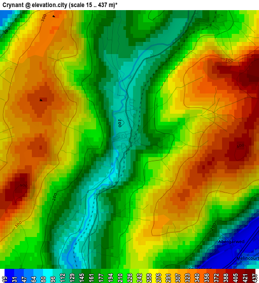
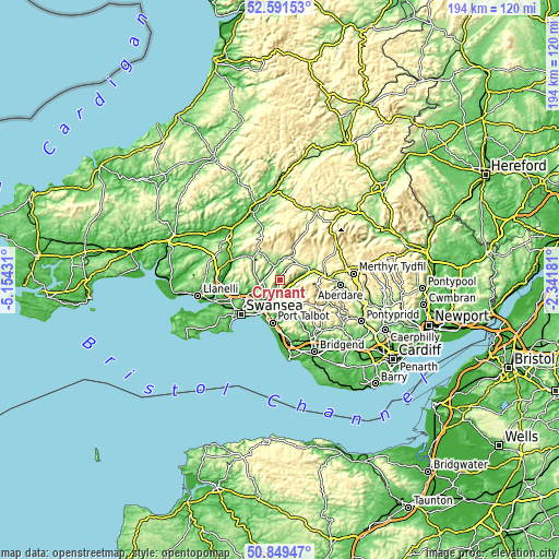
Below is the Elevation map of Crynant, which displays elevation range with different colors. Scale of the first map is from 15 to 437 m (49 to 1434 ft) with average elevation of 234.2 meters (=768 ft) [note 1]
These maps also provides idea of topography and contour of this city, they are displayed at different zoom levels. More info about maps, scale and edge coordinates you can find below images.
| \ | Map #1 | Topo.Map |
| Scale [m] | 15..437 m | × |
| Scale [ft] | 49..1434 ft | × |
| Average | 234.2 m = 768 ft | × |
| Width | 6.05 km = 3.8 mi | 193.7 km = 120.4 mi |
| Height | 6.05 km = 3.8 mi | 193.7 km = 120.4 mi |
| ↑Max Latitude | 51.756101° | 52.59153° |
| Latitude at center | 51.72889° | 51.72889° |
| ↓Min Latitude | 51.701663° | 50.84947° |
| ← Min Longitude | -3.792005° | -5.15431° |
| Longitude center | -3.74806° | -3.74806° |
| →Max Longitude | -3.704115° | -2.34181° |
Nearby cities:
Cities around Crynant sort by population:
• Neath elevation 13 m
8.3 km,  207°
207°
• Briton Ferry 25 m
11.9 km,  204°
204°
• Clydach 12 m
11.6 km,  244°
244°
• Ystalyfera 74 m
4.8 km,  332°
332°
• Brynamman 214 m
11.4 km,  314°
314°
• Glyn-neath 62 m
9.2 km,  76°
76°
• Cwmafan 50 m
12.5 km,  184°
184°
• Seven Sisters 166 m
4.7 km,  27°
27°
• Resolven 28 m
4 km,  118°
118°
• Croeserw 271 m
11.9 km,  141°
141°
• Glyncorrwg 218 m
9.9 km, 123°
• Ystradgynlais 68 m
4.4 km,  343°
343°
Multilingual:
 En español:
Crynant elevación 112 m.
 En France:
Crynant élévation 112 m.


Sources and notes:
- [note 1] Map square and city borders are not equal. Map elevation data is calculated only from area inside that square.
- [src 1] Elevation data from geonames database provided with same terms of usage.
- [src 2] The elevation map of Crynant is generated using elevation data from NASA's 3 arcsec (90m) resolution SRTM data.
- [src 3] Base (background) map © OpenStreetMap contributors tiles are generated by Geofabrik and OpenTopoMap.
Copyright & License:
This Crynant Elevation Map is licensed under CC BY-SA. You may reuse any part from this page, if you give a proper credit by linking to this URL:
 More info on terms of use page.