Crumlin elevation
Crumlin (Northern Ireland, Antrim and Newtownabbey), United Kingdom elevation is 73 meters and Crumlin elevation in feet is 240 ft above sea level [src 1]. Crumlin is a populated place (feature code) with elevation that is 1 meters (3 ft) bigger than average city elevation in United Kingdom.
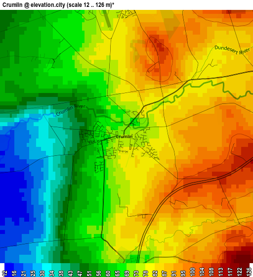
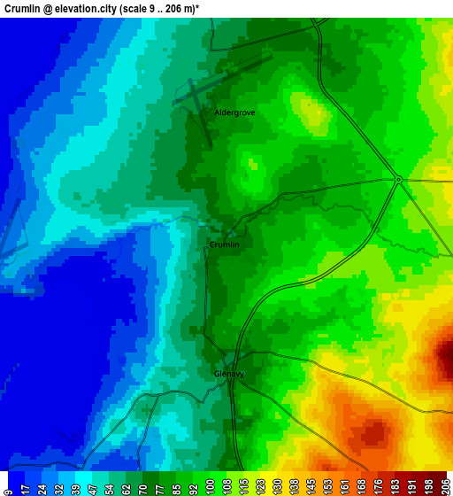
Below is the Elevation map of Crumlin, which displays elevation range with different colors. Scale of the first map is from 12 to 126 m (39 to 413 ft) with average elevation of 71.5 meters (=235 ft) [note 1]
These maps also provides idea of topography and contour of this city, they are displayed at different zoom levels. More info about maps, scale and edge coordinates you can find below images.
| \ | Map #1 | Map #2 | Topo.Map |
| Scale [m] | 12..126 m | 9..206 m | × |
| Scale [ft] | 39..413 ft | 30..676 ft | × |
| Average | 71.5 m = 235 ft | 71.4 m = 234 ft | × |
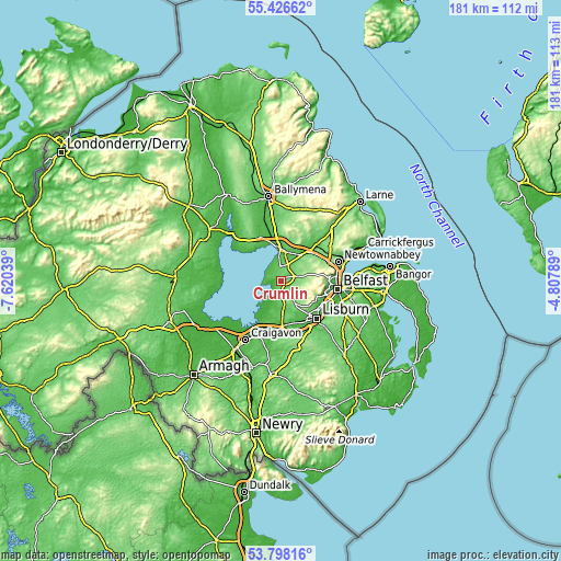
| Width | 5.66 km = 3.5 mi | 11.32 km = 7 mi | 181.1 km = 112.5 mi |
| Height | 5.66 km = 3.5 mi | 11.32 km = 7 mi | 181 km = 112.5 mi |
| ↑Max Latitude | 54.645976° | 54.671396° | 55.42662° |
| Latitude at center | 54.62054° | 54.62054° | 54.62054° |
| ↓Min Latitude | 54.595088° | 54.56962° | 53.79816° |
| ← Min Longitude | -6.258085° | -6.302031° | -7.62039° |
| Longitude center | -6.21414° | -6.21414° | -6.21414° |
| →Max Longitude | -6.170195° | -6.126249° | -4.80789° |
Nearby cities:
Cities around Crumlin sort by population:
• Belfast elevation 7 m
18.8 km,  98°
98°
• Lisburn 53 m
15.8 km,  133°
133°
• Antrim 42 m
8.9 km,  5°
5°
• Randalstown 40 m
15.4 km,  339°
339°
• Moira 69 m
15.6 km,  183°
183°
• Hillsborough 113 m
19.6 km,  153°
153°
• Carnmoney 152 m
18.4 km,  67°
67°
• Connor 100 m
20 km,  2°
2°
• Templepatrick 145 m
10.9 km,  50°
50°
• Magheralin 38 m
17.3 km,  189°
189°
• Doagh 141 m
16.7 km,  30°
30°
• Glenavy 71 m
3.1 km, 179°
Multilingual:
 En español:
Crumlin elevación 73 m.
 En France:
Crumlin élévation 73 m.


Sources and notes:
- [note 1] Map square and city borders are not equal. Map elevation data is calculated only from area inside that square.
- [src 1] Elevation data from geonames database provided with same terms of usage.
- [src 2] The elevation map of Crumlin is generated using elevation data from NASA's 3 arcsec (90m) resolution SRTM data.
- [src 3] Base (background) map © OpenStreetMap contributors tiles are generated by Geofabrik and OpenTopoMap.
Copyright & License:
This Crumlin Elevation Map is licensed under CC BY-SA. You may reuse any part from this page, if you give a proper credit by linking to this URL:
 More info on terms of use page.