Connor elevation
Connor (Northern Ireland, Mid and East Antrim), United Kingdom elevation is 100 meters and Connor elevation in feet is 328 ft above sea level [src 1]. Connor is a populated place (feature code) with elevation that is 28 meters (92 ft) bigger than average city elevation in United Kingdom.
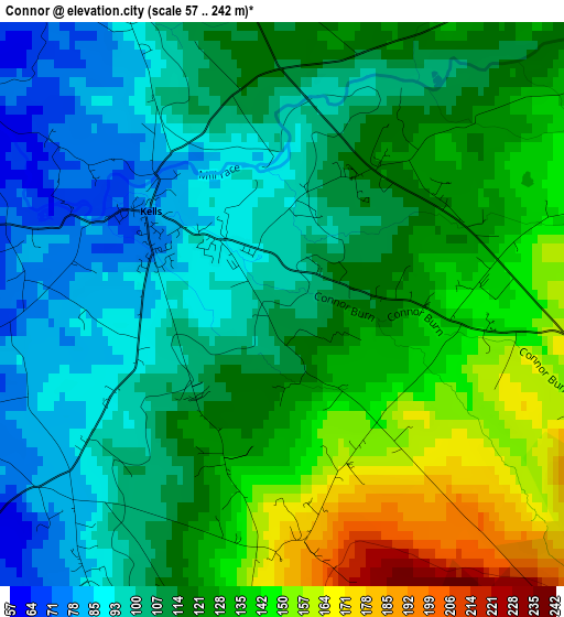
Below is the Elevation map of Connor, which displays elevation range with different colors. Scale of the first map is from 57 to 242 m (187 to 794 ft) with average elevation of 117.3 meters (=385 ft) [note 1]
These maps also provides idea of topography and contour of this city, they are displayed at different zoom levels. More info about maps, scale and edge coordinates you can find below images.
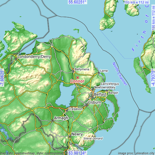
| \ | Map #1 | Topo.Map |
| Scale [m] | 57..242 m | × |
| Scale [ft] | 187..794 ft | × |
| Average | 117.3 m = 385 ft | × |
| Width | 5.63 km = 3.5 mi | 180.3 km = 112 mi |
| Height | 5.63 km = 3.5 mi | 180.3 km = 112 mi |
| ↑Max Latitude | 54.825324° | 55.60251° |
| Latitude at center | 54.8° | 54.8° |
| ↓Min Latitude | 54.774661° | 53.98124° |
| ← Min Longitude | -6.243945° | -7.60625° |
| Longitude center | -6.2° | -6.2° |
| →Max Longitude | -6.156055° | -4.79375° |
Nearby cities:
Cities around Connor sort by population:
• Ballymena elevation 49 m
8.6 km,  325°
325°
• Antrim 42 m
11.1 km,  180°
180°
• Ballyclare 74 m
14 km,  113°
113°
• Randalstown 40 m
8.5 km,  229°
229°
• Crumlin 73 m
20 km, 182°
• Ahoghill 85 m
13 km,  304°
304°
• Broughshane 65 m
10.3 km,  356°
356°
• Cullybackey 72 m
13.6 km,  316°
316°
• Templepatrick 145 m
15 km,  150°
150°
• Portglenone 32 m
19.1 km,  294°
294°
• Doagh 141 m
9.3 km,  126°
126°
• Bellaghy 26 m
20.5 km,  272°
272°
Multilingual:
 En español:
Connor elevación 100 m.
 En France:
Connor élévation 100 m.


Sources and notes:
- [note 1] Map square and city borders are not equal. Map elevation data is calculated only from area inside that square.
- [src 1] Elevation data from geonames database provided with same terms of usage.
- [src 2] The elevation map of Connor is generated using elevation data from NASA's 3 arcsec (90m) resolution SRTM data.
- [src 3] Base (background) map © OpenStreetMap contributors tiles are generated by Geofabrik and OpenTopoMap.
Copyright & License:
This Connor Elevation Map is licensed under CC BY-SA. You may reuse any part from this page, if you give a proper credit by linking to this URL:
 More info on terms of use page.