Moira elevation
Moira (Northern Ireland, Lisburn and Castlereagh), United Kingdom elevation is 69 meters and Moira elevation in feet is 226 ft above sea level [src 1]. Moira is a populated place (feature code) with elevation that is 3 meters (10 ft) smaller than average city elevation in United Kingdom.
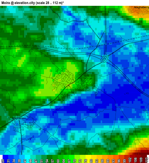
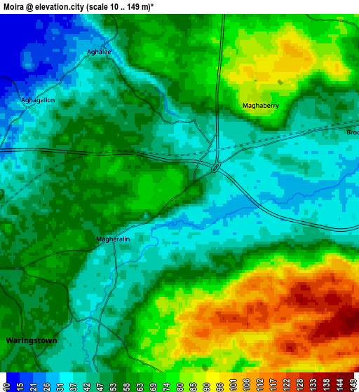
Below is the Elevation map of Moira, which displays elevation range with different colors. Scale of the first map is from 28 to 112 m (92 to 367 ft) with average elevation of 47.9 meters (=157 ft) [note 1]
These maps also provides idea of topography and contour of this city, they are displayed at different zoom levels. More info about maps, scale and edge coordinates you can find below images.
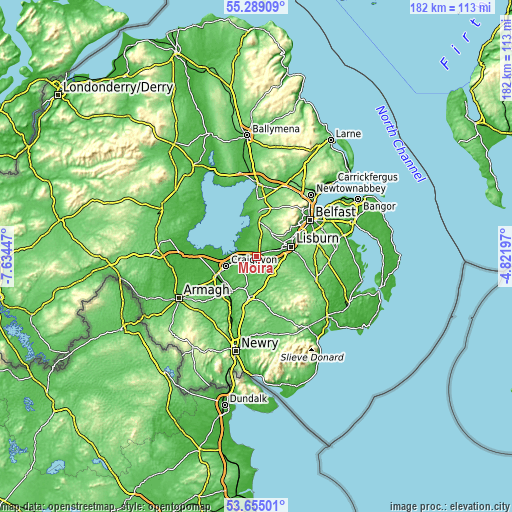
| \ | Map #1 | Map #2 | Topo.Map |
| Scale [m] | 28..112 m | 10..149 m | × |
| Scale [ft] | 92..367 ft | 33..489 ft | × |
| Average | 47.9 m = 157 ft | 59.3 m = 195 ft | × |
| Width | 5.68 km = 3.5 mi | 11.36 km = 7.1 mi | 181.7 km = 112.9 mi |
| Height | 5.68 km = 3.5 mi | 11.36 km = 7.1 mi | 181.7 km = 112.9 mi |
| ↑Max Latitude | 54.505734° | 54.531241° | 55.28909° |
| Latitude at center | 54.48021° | 54.48021° | 54.48021° |
| ↓Min Latitude | 54.454671° | 54.429115° | 53.65501° |
| ← Min Longitude | -6.272165° | -6.316111° | -7.63447° |
| Longitude center | -6.22822° | -6.22822° | -6.22822° |
| →Max Longitude | -6.184275° | -6.140329° | -4.82197° |
Nearby cities:
Cities around Moira sort by population:
• Lisburn elevation 53 m
13.4 km,  68°
68°
• Craigavon 34 m
10.9 km,  250°
250°
• Portadown 22 m
15.4 km, 245°
• Banbridge 94 m
14.9 km,  193°
193°
• Crumlin 73 m
15.6 km,  3°
3°
• Hillsborough 113 m
10 km,  100°
100°
• Tandragee 63 m
18.4 km,  220°
220°
• Waringstown 50 m
6.9 km, 221°
• Gilford 28 m
14.7 km, 215°
• Magheralin 38 m
2.5 km,  234°
234°
• Annahilt 92 m
15.6 km,  109°
109°
• Glenavy 71 m
12.5 km, 4°
Multilingual:
 En español:
Moira elevación 69 m.
 En France:
Moira élévation 69 m.


Sources and notes:
- [note 1] Map square and city borders are not equal. Map elevation data is calculated only from area inside that square.
- [src 1] Elevation data from geonames database provided with same terms of usage.
- [src 2] The elevation map of Moira is generated using elevation data from NASA's 3 arcsec (90m) resolution SRTM data.
- [src 3] Base (background) map © OpenStreetMap contributors tiles are generated by Geofabrik and OpenTopoMap.
Copyright & License:
This Moira Elevation Map is licensed under CC BY-SA. You may reuse any part from this page, if you give a proper credit by linking to this URL:
 More info on terms of use page.