Disley elevation
Disley (England, Cheshire East), United Kingdom elevation is 191 meters and Disley elevation in feet is 627 ft above sea level [src 1]. Disley is a seat of a third-order administrative division (feature code) with elevation that is 119 meters (390 ft) bigger than average city elevation in United Kingdom.
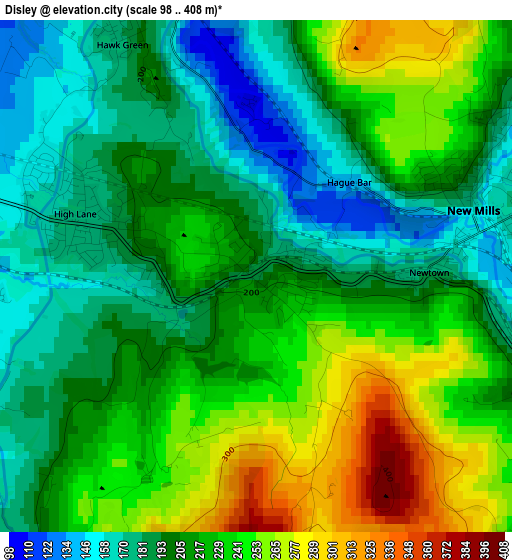
Below is the Elevation map of Disley, which displays elevation range with different colors. Scale of the first map is from 98 to 408 m (322 to 1339 ft) with average elevation of 214.6 meters (=704 ft) [note 1]
These maps also provides idea of topography and contour of this city, they are displayed at different zoom levels. More info about maps, scale and edge coordinates you can find below images.
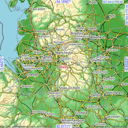
| \ | Map #1 | Topo.Map |
| Scale [m] | 98..408 m | × |
| Scale [ft] | 322..1339 ft | × |
| Average | 214.6 m = 704 ft | × |
| Width | 5.83 km = 3.6 mi | 186.6 km = 115.9 mi |
| Height | 5.83 km = 3.6 mi | 186.6 km = 115.9 mi |
| ↑Max Latitude | 53.384869° | 54.18967° |
| Latitude at center | 53.35865° | 53.35865° |
| ↓Min Latitude | 53.332415° | 52.51111° |
| ← Min Longitude | -2.082425° | -3.44473° |
| Longitude center | -2.03848° | -2.03848° |
| →Max Longitude | -1.994535° | -0.63223° |
Nearby cities:
Cities around Disley sort by population:
• Bramhall elevation 83 m
8.4 km,  269°
269°
• Marple 147 m
4.3 km,  337°
337°
• New Mills 156 m
2.7 km,  72°
72°
• Hazel Grove 88 m
5.9 km,  297°
297°
• Bredbury 91 m
8.3 km,  321°
321°
• Poynton 97 m
5.3 km,  259°
259°
• Bollington 143 m
8.6 km,  213°
213°
• Whaley Bridge 170 m
4.9 km,  130°
130°
• Hayfield 193 m
6.6 km, 69°
• Chinley 208 m
6.9 km,  107°
107°
• Adlington 105 m
7.8 km,  236°
236°
• Pott Shrigley 198 m
6.2 km, 209°
Multilingual:
 En español:
Disley elevación 191 m.
 En France:
Disley élévation 191 m.


Sources and notes:
- [note 1] Map square and city borders are not equal. Map elevation data is calculated only from area inside that square.
- [src 1] Elevation data from geonames database provided with same terms of usage.
- [src 2] The elevation map of Disley is generated using elevation data from NASA's 3 arcsec (90m) resolution SRTM data.
- [src 3] Base (background) map © OpenStreetMap contributors tiles are generated by Geofabrik and OpenTopoMap.
Copyright & License:
This Disley Elevation Map is licensed under CC BY-SA. You may reuse any part from this page, if you give a proper credit by linking to this URL:
 More info on terms of use page.