Bramhall elevation
Bramhall (England, Borough of Stockport), United Kingdom elevation is 83 meters and Bramhall elevation in feet is 272 ft above sea level [src 1]. Bramhall is a populated place (feature code) with elevation that is 11 meters (36 ft) bigger than average city elevation in United Kingdom.
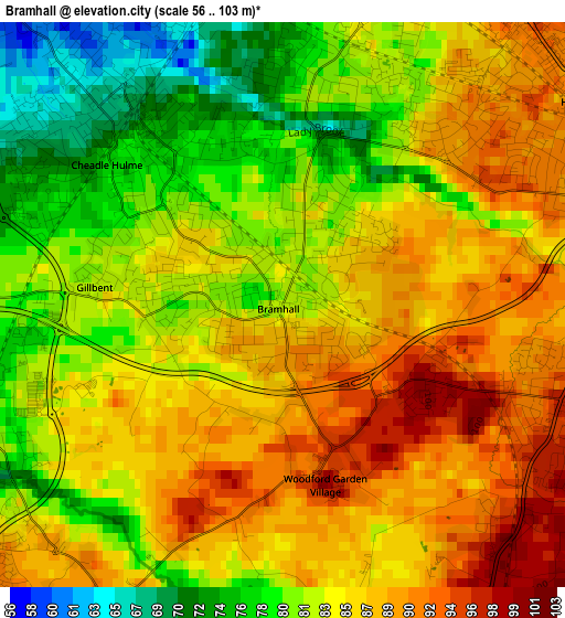
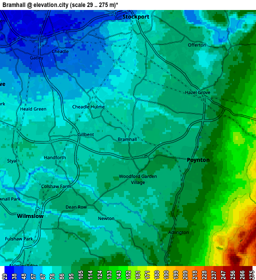
Below is the Elevation map of Bramhall, which displays elevation range with different colors. Scale of the first map is from 56 to 103 m (184 to 338 ft) with average elevation of 84.1 meters (=276 ft) [note 1]
These maps also provides idea of topography and contour of this city, they are displayed at different zoom levels. More info about maps, scale and edge coordinates you can find below images.
| \ | Map #1 | Map #2 | Topo.Map |
| Scale [m] | 56..103 m | 29..275 m | × |
| Scale [ft] | 184..338 ft | 95..902 ft | × |
| Average | 84.1 m = 276 ft | 90.2 m = 296 ft | × |
| Width | 5.83 km = 3.6 mi | 11.66 km = 7.2 mi | 186.6 km = 115.9 mi |
| Height | 5.83 km = 3.6 mi | 11.66 km = 7.2 mi | 186.6 km = 115.9 mi |
| ↑Max Latitude | 53.384229° | 53.410432° | 54.18904° |
| Latitude at center | 53.35801° | 53.35801° | 53.35801° |
| ↓Min Latitude | 53.331775° | 53.305523° | 52.51045° |
| ← Min Longitude | -2.209335° | -2.253281° | -3.57164° |
| Longitude center | -2.16539° | -2.16539° | -2.16539° |
| →Max Longitude | -2.121445° | -2.077499° | -0.75914° |
Nearby cities:
Cities around Bramhall sort by population:
• Stockport elevation 59 m
5.8 km,  5°
5°
• Wilmslow 79 m
5.5 km,  232°
232°
• Cheadle Hulme 68 m
2.6 km,  321°
321°
• Marple 147 m
7.9 km,  59°
59°
• Hazel Grove 88 m
4.3 km,  48°
48°
• Bredbury 91 m
7.3 km,  26°
26°
• Poynton 97 m
3.4 km,  105°
105°
• Alderley Edge 87 m
7.7 km,  218°
218°
• Cheadle Heath 49 m
5.2 km,  340°
340°
• Adlington 105 m
4.6 km,  155°
155°
• Pott Shrigley 198 m
7.6 km,  134°
134°
• Mottram St. Andrew 115 m
5.9 km,  190°
190°
Multilingual:
 En español:
Bramhall elevación 83 m.
 En France:
Bramhall élévation 83 m.


Sources and notes:
- [note 1] Map square and city borders are not equal. Map elevation data is calculated only from area inside that square.
- [src 1] Elevation data from geonames database provided with same terms of usage.
- [src 2] The elevation map of Bramhall is generated using elevation data from NASA's 3 arcsec (90m) resolution SRTM data.
- [src 3] Base (background) map © OpenStreetMap contributors tiles are generated by Geofabrik and OpenTopoMap.
Copyright & License:
This Bramhall Elevation Map is licensed under CC BY-SA. You may reuse any part from this page, if you give a proper credit by linking to this URL:
 More info on terms of use page.