Kings Sutton elevation
Kings Sutton (England, Northamptonshire), United Kingdom elevation is 90 meters and Kings Sutton elevation in feet is 295 ft above sea level [src 1]. Kings Sutton is a populated place (feature code) with elevation that is 18 meters (59 ft) bigger than average city elevation in United Kingdom.
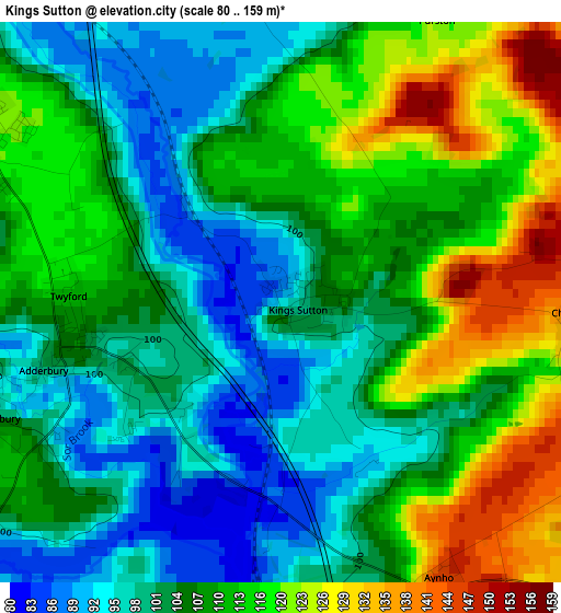
Below is the Elevation map of Kings Sutton, which displays elevation range with different colors. Scale of the first map is from 80 to 159 m (262 to 522 ft) with average elevation of 108.1 meters (=355 ft) [note 1]
These maps also provides idea of topography and contour of this city, they are displayed at different zoom levels. More info about maps, scale and edge coordinates you can find below images.
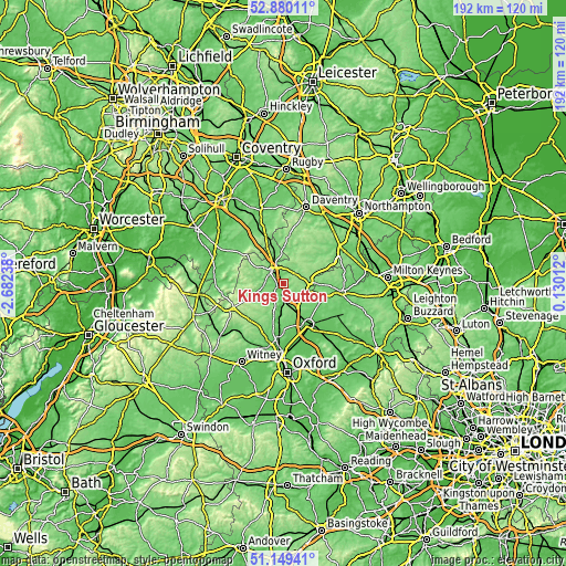
| \ | Map #1 | Topo.Map |
| Scale [m] | 80..159 m | × |
| Scale [ft] | 262..522 ft | × |
| Average | 108.1 m = 355 ft | × |
| Width | 6.01 km = 3.7 mi | 192.4 km = 119.6 mi |
| Height | 6.01 km = 3.7 mi | 192.4 km = 119.6 mi |
| ↑Max Latitude | 52.050163° | 52.88011° |
| Latitude at center | 52.02313° | 52.02313° |
| ↓Min Latitude | 51.99608° | 51.14941° |
| ← Min Longitude | -1.320075° | -2.68238° |
| Longitude center | -1.27613° | -1.27613° |
| →Max Longitude | -1.232185° | 0.13012° |
Nearby cities:
Cities around Kings Sutton sort by population:
• Banbury elevation 100 m
6.3 km,  314°
314°
• Bicester 75 m
16.1 km,  148°
148°
• Brackley 145 m
8.7 km,  82°
82°
• Somerton 112 m
7.7 km,  180°
180°
• Claydon 137 m
14.4 km,  344°
344°
• Hinton 135 m
16.6 km,  13°
13°
• Bloxham 112 m
6.6 km,  267°
267°
• Adderbury 104 m
2.5 km,  254°
254°
• Farnborough 155 m
14.8 km,  334°
334°
• Hook Norton 158 m
14.5 km,  257°
257°
• Deddington 128 m
5.6 km,  212°
212°
• Tingewick 109 m
16 km,  103°
103°
Multilingual:
 En español:
Kings Sutton elevación 90 m.
 En France:
Kings Sutton élévation 90 m.
 Auf Deutsch:
Kings Sutton höhe über dem Meeresspiegel ist 90 m.

Sources and notes:
- [note 1] Map square and city borders are not equal. Map elevation data is calculated only from area inside that square.
- [src 1] Elevation data from geonames database provided with same terms of usage.
- [src 2] The elevation map of Kings Sutton is generated using elevation data from NASA's 3 arcsec (90m) resolution SRTM data.
- [src 3] Base (background) map © OpenStreetMap contributors tiles are generated by Geofabrik and OpenTopoMap.
Copyright & License:
This Kings Sutton Elevation Map is licensed under CC BY-SA. You may reuse any part from this page, if you give a proper credit by linking to this URL:
 More info on terms of use page.