Luton elevation
Luton (England), United Kingdom elevation is 117 meters and Luton elevation in feet is 384 ft above sea level [src 1]. Luton is a seat of a second-order administrative division (feature code) with elevation that is 45 meters (148 ft) bigger than average city elevation in United Kingdom.
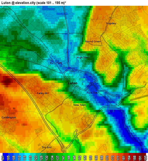
Below is the Elevation map of Luton, which displays elevation range with different colors. Scale of the first map is from 101 to 195 m (331 to 640 ft) with average elevation of 143.8 meters (=472 ft) [note 1]
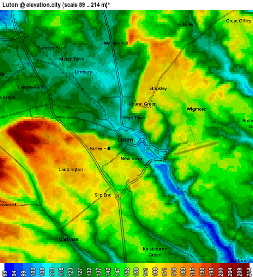
These maps also provides idea of topography and contour of this city, they are displayed at different zoom levels. More info about maps, scale and edge coordinates you can find below images.
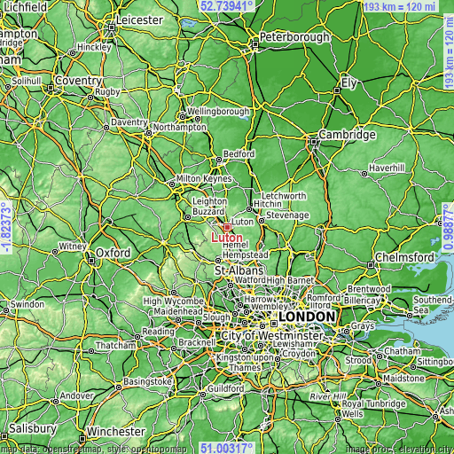
| \ | Map #1 | Map #2 | Topo.Map |
| Scale [m] | 101..195 m | 89..214 m | × |
| Scale [ft] | 331..640 ft | 292..702 ft | × |
| Average | 143.8 m = 472 ft | 144.7 m = 475 ft | × |
| Width | 6.03 km = 3.7 mi | 12.07 km = 7.5 mi | 193.1 km = 120 mi |
| Height | 6.03 km = 3.7 mi | 12.07 km = 7.5 mi | 193 km = 119.9 mi |
| ↑Max Latitude | 51.90679° | 51.933893° | 52.73941° |
| Latitude at center | 51.87967° | 51.87967° | 51.87967° |
| ↓Min Latitude | 51.852534° | 51.825381° | 51.00317° |
| ← Min Longitude | -0.461425° | -0.505371° | -1.82373° |
| Longitude center | -0.41748° | -0.41748° | -0.41748° |
| →Max Longitude | -0.373535° | -0.329589° | 0.98877° |
Nearby cities:
Cities around Luton sort by population:
• Dunstable elevation 150 m
7.3 km,  275°
275°
• Harpenden 107 m
8.1 km,  149°
149°
• Redbourn 102 m
9.1 km,  170°
170°
• Barton-le-Clay 70 m
9.6 km,  355°
355°
• Caddington 176 m
3.1 km,  240°
240°
• Markyate 133 m
5.6 km,  214°
214°
• Harlington 107 m
10.6 km,  330°
330°
• Kensworth 188 m
6.7 km, 242°
• Kimpton 90 m
8.7 km,  111°
111°
• Streatley 151 m
7.6 km,  346°
346°
• Chalton 108 m
7.9 km,  312°
312°
• Houghton Regis 134 m
7.6 km,  291°
291°
Multilingual:
 En español:
Luton elevación 117 m.
 En France:
Luton élévation 117 m.


Sources and notes:
- [note 1] Map square and city borders are not equal. Map elevation data is calculated only from area inside that square.
- [src 1] Elevation data from geonames database provided with same terms of usage.
- [src 2] The elevation map of Luton is generated using elevation data from NASA's 3 arcsec (90m) resolution SRTM data.
- [src 3] Base (background) map © OpenStreetMap contributors tiles are generated by Geofabrik and OpenTopoMap.
Copyright & License:
This Luton Elevation Map is licensed under CC BY-SA. You may reuse any part from this page, if you give a proper credit by linking to this URL:
 More info on terms of use page.