Ringway elevation
Ringway (England, Manchester), United Kingdom elevation is 71 meters and Ringway elevation in feet is 233 ft above sea level [src 1]. Ringway is a seat of a third-order administrative division (feature code) with elevation that is 1 meters (3 ft) smaller than average city elevation in United Kingdom.
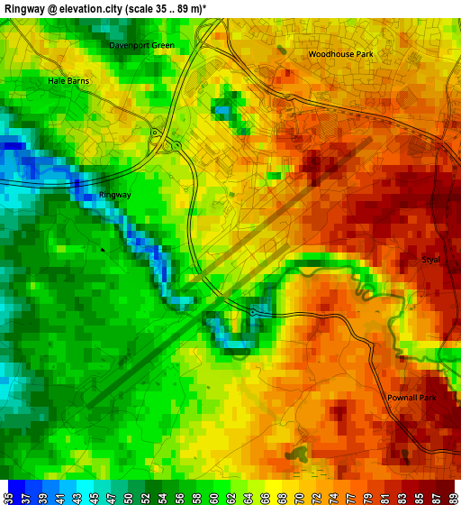
Below is the Elevation map of Ringway, which displays elevation range with different colors. Scale of the first map is from 35 to 89 m (115 to 292 ft) with average elevation of 66.5 meters (=218 ft) [note 1]
These maps also provides idea of topography and contour of this city, they are displayed at different zoom levels. More info about maps, scale and edge coordinates you can find below images.
| \ | Map #1 | Topo.Map |
| Scale [m] | 35..89 m | × |
| Scale [ft] | 115..292 ft | × |
| Average | 66.5 m = 218 ft | × |
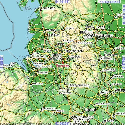
| Width | 5.83 km = 3.6 mi | 186.7 km = 116 mi |
| Height | 5.83 km = 3.6 mi | 186.7 km = 116 mi |
| ↑Max Latitude | 53.376224° | 54.18119° |
| Latitude at center | 53.35° | 53.35° |
| ↓Min Latitude | 53.32376° | 52.50229° |
| ← Min Longitude | -2.327275° | -3.68958° |
| Longitude center | -2.28333° | -2.28333° |
| →Max Longitude | -2.239385° | -0.87708° |
Nearby cities:
Cities around Ringway sort by population:
• Altrincham elevation 42 m
6 km,  313°
313°
• Wilmslow 79 m
4.2 km,  125°
125°
• Cheadle Hulme 68 m
6.9 km,  64°
64°
• Bramhall 83 m
7.9 km,  83°
83°
• Hale 47 m
4.5 km, 313°
• Didsbury 40 m
8.2 km,  24°
24°
• Knutsford 68 m
8 km,  229°
229°
• Timperley 30 m
6.5 km,  329°
329°
• Bowdon 58 m
6.2 km,  298°
298°
• Alderley Edge 87 m
6 km,  149°
149°
• Mobberley 58 m
4.3 km,  210°
210°
• Ashley 46 m
3.3 km,  270°
270°
Multilingual:
 En español:
Ringway elevación 71 m.
 En France:
Ringway élévation 71 m.


Sources and notes:
- [note 1] Map square and city borders are not equal. Map elevation data is calculated only from area inside that square.
- [src 1] Elevation data from geonames database provided with same terms of usage.
- [src 2] The elevation map of Ringway is generated using elevation data from NASA's 3 arcsec (90m) resolution SRTM data.
- [src 3] Base (background) map © OpenStreetMap contributors tiles are generated by Geofabrik and OpenTopoMap.
Copyright & License:
This Ringway Elevation Map is licensed under CC BY-SA. You may reuse any part from this page, if you give a proper credit by linking to this URL:
 More info on terms of use page.