Hale elevation
Hale (England, Manchester), United Kingdom elevation is 47 meters and Hale elevation in feet is 154 ft above sea level [src 1]. Hale is a populated place (feature code) with elevation that is 25 meters (82 ft) smaller than average city elevation in United Kingdom.
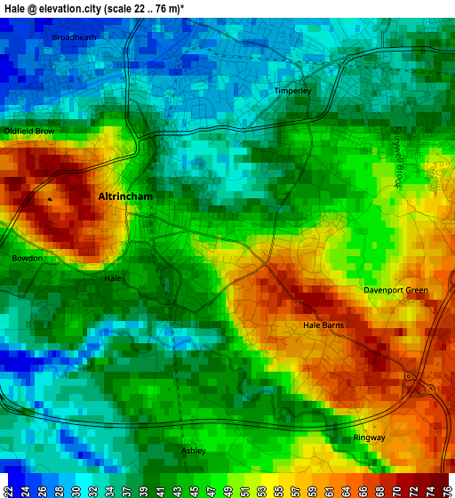
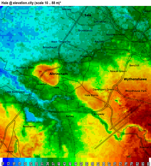
Below is the Elevation map of Hale, which displays elevation range with different colors. Scale of the first map is from 22 to 76 m (72 to 249 ft) with average elevation of 44.5 meters (=146 ft) [note 1]
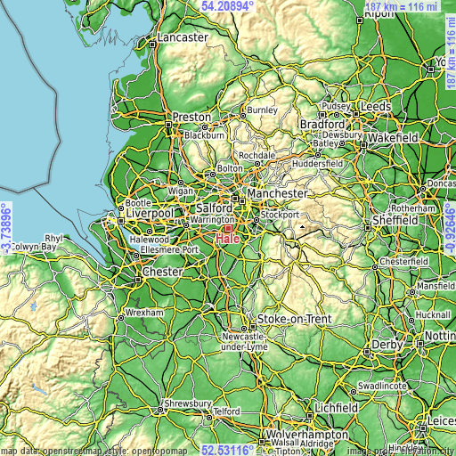
These maps also provides idea of topography and contour of this city, they are displayed at different zoom levels. More info about maps, scale and edge coordinates you can find below images.
| \ | Map #1 | Map #2 | Topo.Map |
| Scale [m] | 22..76 m | 10..88 m | × |
| Scale [ft] | 72..249 ft | 33..289 ft | × |
| Average | 44.5 m = 146 ft | 44 m = 144 ft | × |
| Width | 5.83 km = 3.6 mi | 11.66 km = 7.2 mi | 186.6 km = 115.9 mi |
| Height | 5.83 km = 3.6 mi | 11.66 km = 7.2 mi | 186.5 km = 115.9 mi |
| ↑Max Latitude | 53.404517° | 53.430707° | 54.20894° |
| Latitude at center | 53.37831° | 53.37831° | 53.37831° |
| ↓Min Latitude | 53.352087° | 53.325848° | 52.53116° |
| ← Min Longitude | -2.376655° | -2.420601° | -3.73896° |
| Longitude center | -2.33271° | -2.33271° | -2.33271° |
| →Max Longitude | -2.288765° | -2.244819° | -0.92646° |
Nearby cities:
Cities around Hale sort by population:
• Sale elevation 30 m
5.2 km,  6°
6°
• Altrincham 42 m
1.5 km,  314°
314°
• Urmston 26 m
7.9 km,  349°
349°
• Timperley 30 m
2.4 km,  359°
359°
• Partington 20 m
7.8 km, 305°
• Bowdon 58 m
2.2 km,  264°
264°
• Chorlton cum Hardy 33 m
7.8 km,  36°
36°
• Mobberley 58 m
6.9 km,  171°
171°
• Mere 72 m
7.2 km,  224°
224°
• Carrington 21 m
7 km,  331°
331°
• Ringway 71 m
4.5 km,  133°
133°
• Ashley 46 m
3.1 km,  180°
180°
Multilingual:
 En español:
Hale elevación 47 m.
 En France:
Hale élévation 47 m.


Sources and notes:
- [note 1] Map square and city borders are not equal. Map elevation data is calculated only from area inside that square.
- [src 1] Elevation data from geonames database provided with same terms of usage.
- [src 2] The elevation map of Hale is generated using elevation data from NASA's 3 arcsec (90m) resolution SRTM data.
- [src 3] Base (background) map © OpenStreetMap contributors tiles are generated by Geofabrik and OpenTopoMap.
Copyright & License:
This Hale Elevation Map is licensed under CC BY-SA. You may reuse any part from this page, if you give a proper credit by linking to this URL:
 More info on terms of use page.