Rothwell elevation
Rothwell (England, Northamptonshire), United Kingdom elevation is 101 meters and Rothwell elevation in feet is 331 ft above sea level [src 1]. Rothwell is a populated place (feature code) with elevation that is 29 meters (95 ft) bigger than average city elevation in United Kingdom.
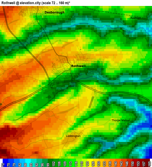
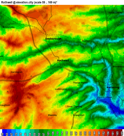
Below is the Elevation map of Rothwell, which displays elevation range with different colors. Scale of the first map is from 72 to 160 m (236 to 525 ft) with average elevation of 116.4 meters (=382 ft) [note 1]
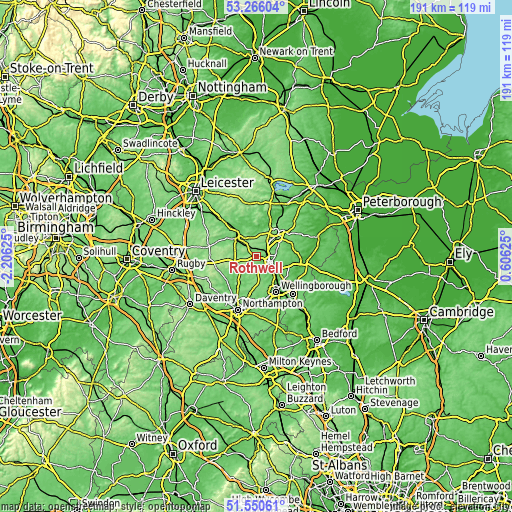
These maps also provides idea of topography and contour of this city, they are displayed at different zoom levels. More info about maps, scale and edge coordinates you can find below images.
| \ | Map #1 | Map #2 | Topo.Map |
| Scale [m] | 72..160 m | 59..169 m | × |
| Scale [ft] | 236..525 ft | 194..554 ft | × |
| Average | 116.4 m = 382 ft | 118.4 m = 388 ft | × |
| Width | 5.96 km = 3.7 mi | 11.92 km = 7.4 mi | 190.7 km = 118.5 mi |
| Height | 5.96 km = 3.7 mi | 11.92 km = 7.4 mi | 190.7 km = 118.5 mi |
| ↑Max Latitude | 52.443465° | 52.470243° | 53.26604° |
| Latitude at center | 52.41667° | 52.41667° | 52.41667° |
| ↓Min Latitude | 52.389859° | 52.363032° | 51.55061° |
| ← Min Longitude | -0.843945° | -0.887891° | -2.20625° |
| Longitude center | -0.8° | -0.8° | -0.8° |
| →Max Longitude | -0.756055° | -0.712109° | 0.60625° |
Nearby cities:
Cities around Rothwell sort by population:
• Kettering elevation 95 m
5.4 km,  111°
111°
• Corby 114 m
11.6 km,  40°
40°
• Market Harborough 81 m
10.6 km,  309°
309°
• Desborough 126 m
3.1 km,  332°
332°
• Burton Latimer 74 m
10.1 km,  125°
125°
• Brixworth 125 m
12 km,  215°
215°
• Finedon 85 m
13.3 km, 130°
• Broughton 116 m
5.1 km,  160°
160°
• Geddington 74 m
7.8 km,  72°
72°
• Brigstock 60 m
13.8 km, 70°
• Cottingham 100 m
10 km,  17°
17°
• Sywell 112 m
13.1 km,  179°
179°
Multilingual:
 En español:
Rothwell elevación 101 m.
 En France:
Rothwell élévation 101 m.
 Auf Deutsch:
Rothwell höhe über dem Meeresspiegel ist 101 m.

Sources and notes:
- [note 1] Map square and city borders are not equal. Map elevation data is calculated only from area inside that square.
- [src 1] Elevation data from geonames database provided with same terms of usage.
- [src 2] The elevation map of Rothwell is generated using elevation data from NASA's 3 arcsec (90m) resolution SRTM data.
- [src 3] Base (background) map © OpenStreetMap contributors tiles are generated by Geofabrik and OpenTopoMap.
Copyright & License:
This Rothwell Elevation Map is licensed under CC BY-SA. You may reuse any part from this page, if you give a proper credit by linking to this URL:
 More info on terms of use page.