Finedon elevation
Finedon (England, Northamptonshire), United Kingdom elevation is 85 meters and Finedon elevation in feet is 279 ft above sea level [src 1]. Finedon is a populated place (feature code) with elevation that is 13 meters (43 ft) bigger than average city elevation in United Kingdom.
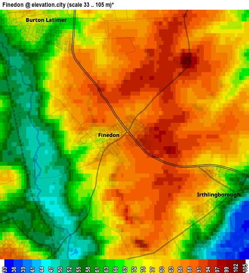
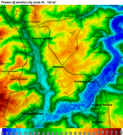
Below is the Elevation map of Finedon, which displays elevation range with different colors. Scale of the first map is from 33 to 105 m (108 to 344 ft) with average elevation of 75.4 meters (=247 ft) [note 1]
These maps also provides idea of topography and contour of this city, they are displayed at different zoom levels. More info about maps, scale and edge coordinates you can find below images.
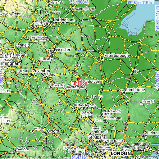
| \ | Map #1 | Map #2 | Topo.Map |
| Scale [m] | 33..105 m | 30..120 m | × |
| Scale [ft] | 108..344 ft | 98..394 ft | × |
| Average | 75.4 m = 247 ft | 70.5 m = 231 ft | × |
| Width | 5.97 km = 3.7 mi | 11.94 km = 7.4 mi | 191.1 km = 118.7 mi |
| Height | 5.97 km = 3.7 mi | 11.94 km = 7.4 mi | 191.1 km = 118.7 mi |
| ↑Max Latitude | 52.366012° | 52.392837° | 53.19004° |
| Latitude at center | 52.33917° | 52.33917° | 52.33917° |
| ↓Min Latitude | 52.312312° | 52.285437° | 51.4716° |
| ← Min Longitude | -0.694025° | -0.737971° | -2.05633° |
| Longitude center | -0.65008° | -0.65008° | -0.65008° |
| →Max Longitude | -0.606135° | -0.562189° | 0.75617° |
Nearby cities:
Cities around Finedon sort by population:
• Kettering elevation 95 m
8.3 km,  322°
322°
• Wellingborough 70 m
5.1 km,  216°
216°
• Rushden 61 m
6.4 km,  149°
149°
• Raunds 54 m
7.7 km,  85°
85°
• Irthlingborough 61 m
3 km,  117°
117°
• Burton Latimer 74 m
3.3 km, 324°
• Higham Ferrers 74 m
5.3 km,  133°
133°
• Irchester 77 m
6.5 km,  176°
176°
• Wollaston 87 m
9.1 km,  188°
188°
• Stanwick 53 m
5.9 km,  97°
97°
• Ringstead 45 m
7.1 km,  65°
65°
• Woodford 66 m
6.7 km,  44°
44°
Multilingual:
 En español:
Finedon elevación 85 m.
 En France:
Finedon élévation 85 m.


Sources and notes:
- [note 1] Map square and city borders are not equal. Map elevation data is calculated only from area inside that square.
- [src 1] Elevation data from geonames database provided with same terms of usage.
- [src 2] The elevation map of Finedon is generated using elevation data from NASA's 3 arcsec (90m) resolution SRTM data.
- [src 3] Base (background) map © OpenStreetMap contributors tiles are generated by Geofabrik and OpenTopoMap.
Copyright & License:
This Finedon Elevation Map is licensed under CC BY-SA. You may reuse any part from this page, if you give a proper credit by linking to this URL:
 More info on terms of use page.