Wellingborough elevation
Wellingborough (England, Northamptonshire), United Kingdom elevation is 70 meters and Wellingborough elevation in feet is 230 ft above sea level [src 1]. Wellingborough is a populated place (feature code) with elevation that is 2 meters (7 ft) smaller than average city elevation in United Kingdom.
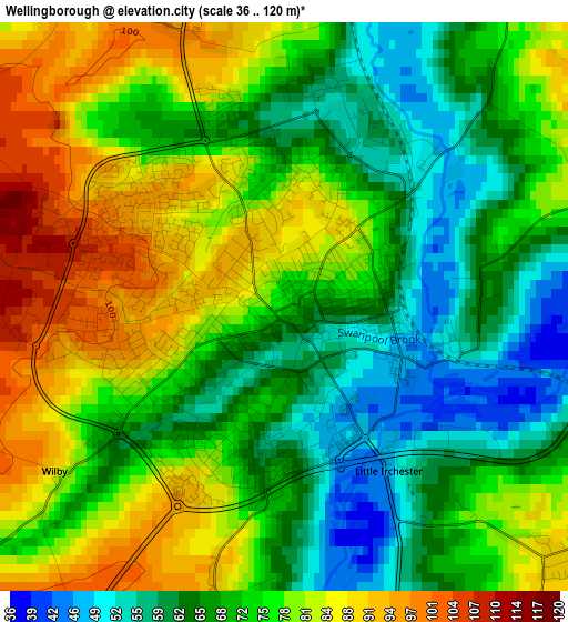
Below is the Elevation map of Wellingborough, which displays elevation range with different colors. Scale of the first map is from 36 to 120 m (118 to 394 ft) with average elevation of 73.4 meters (=241 ft) [note 1]
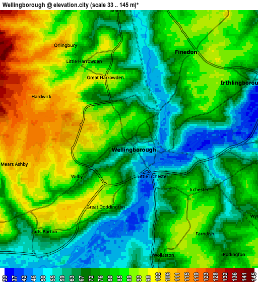
These maps also provides idea of topography and contour of this city, they are displayed at different zoom levels. More info about maps, scale and edge coordinates you can find below images.
| \ | Map #1 | Map #2 | Topo.Map |
| Scale [m] | 36..120 m | 33..145 m | × |
| Scale [ft] | 118..394 ft | 108..476 ft | × |
| Average | 73.4 m = 241 ft | 79.3 m = 260 ft | × |
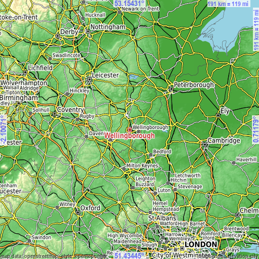
| Width | 5.98 km = 3.7 mi | 11.95 km = 7.4 mi | 191.2 km = 118.8 mi |
| Height | 5.98 km = 3.7 mi | 11.95 km = 7.4 mi | 191.2 km = 118.8 mi |
| ↑Max Latitude | 52.329594° | 52.356442° | 53.15431° |
| Latitude at center | 52.30273° | 52.30273° | 52.30273° |
| ↓Min Latitude | 52.27585° | 52.248953° | 51.43445° |
| ← Min Longitude | -0.738405° | -0.782351° | -2.10071° |
| Longitude center | -0.69446° | -0.69446° | -0.69446° |
| →Max Longitude | -0.650515° | -0.606569° | 0.71179° |
Nearby cities:
Cities around Wellingborough sort by population:
• Rushden elevation 61 m
6.5 km,  103°
103°
• Irthlingborough 61 m
6.3 km,  64°
64°
• Burton Latimer 74 m
6.9 km,  9°
9°
• Higham Ferrers 74 m
6.9 km,  87°
87°
• Earls Barton 94 m
5.7 km,  224°
224°
• Irchester 77 m
4.1 km,  125°
125°
• Finedon 85 m
5.1 km,  36°
36°
• Wollaston 87 m
5.2 km,  161°
161°
• Bozeat 84 m
9 km,  170°
170°
• Stanwick 53 m
9.5 km,  69°
69°
• Sywell 112 m
7 km,  266°
266°
• Podington 75 m
7.2 km,  138°
138°
Multilingual:
 En español:
Wellingborough elevación 70 m.
 En France:
Wellingborough élévation 70 m.
 Auf Deutsch:
Wellingborough höhe über dem Meeresspiegel ist 70 m.
 На русском:
Веллингборо, Уэллингборо высота над уровнем моря 70 м
Sources and notes:
- [note 1] Map square and city borders are not equal. Map elevation data is calculated only from area inside that square.
- [src 1] Elevation data from geonames database provided with same terms of usage.
- [src 2] The elevation map of Wellingborough is generated using elevation data from NASA's 3 arcsec (90m) resolution SRTM data.
- [src 3] Base (background) map © OpenStreetMap contributors tiles are generated by Geofabrik and OpenTopoMap.
Copyright & License:
This Wellingborough Elevation Map is licensed under CC BY-SA. You may reuse any part from this page, if you give a proper credit by linking to this URL:
 More info on terms of use page.