Stokenchurch elevation
Stokenchurch (England, Buckinghamshire), United Kingdom elevation is 223 meters and Stokenchurch elevation in feet is 732 ft above sea level [src 1]. Stokenchurch is a populated place (feature code) with elevation that is 151 meters (495 ft) bigger than average city elevation in United Kingdom.
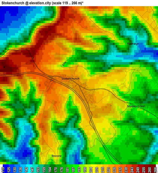
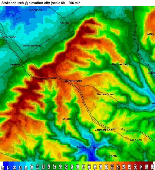
Below is the Elevation map of Stokenchurch, which displays elevation range with different colors. Scale of the first map is from 119 to 266 m (390 to 873 ft) with average elevation of 193.2 meters (=634 ft) [note 1]
These maps also provides idea of topography and contour of this city, they are displayed at different zoom levels. More info about maps, scale and edge coordinates you can find below images.
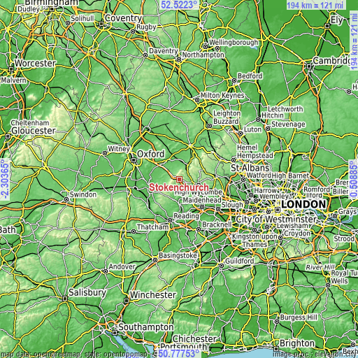
| \ | Map #1 | Map #2 | Topo.Map |
| Scale [m] | 119..266 m | 69..266 m | × |
| Scale [ft] | 390..873 ft | 226..873 ft | × |
| Average | 193.2 m = 634 ft | 162.8 m = 534 ft | × |
| Width | 6.06 km = 3.8 mi | 12.12 km = 7.5 mi | 194 km = 120.5 mi |
| Height | 6.06 km = 3.8 mi | 12.12 km = 7.5 mi | 194 km = 120.5 mi |
| ↑Max Latitude | 51.685563° | 51.7128° | 52.5223° |
| Latitude at center | 51.65831° | 51.65831° | 51.65831° |
| ↓Min Latitude | 51.63104° | 51.603754° | 50.77753° |
| ← Min Longitude | -0.941345° | -0.985291° | -2.30365° |
| Longitude center | -0.8974° | -0.8974° | -0.8974° |
| →Max Longitude | -0.853455° | -0.809509° | 0.50885° |
Nearby cities:
Cities around Stokenchurch sort by population:
• High Wycombe elevation 76 m
10.7 km,  107°
107°
• Marlow 32 m
13 km,  139°
139°
• Thame 72 m
11.4 km,  331°
331°
• Princes Risborough 112 m
8.7 km,  31°
31°
• Chinnor 120 m
4.9 km,  348°
348°
• Haddenham 79 m
12.9 km, 351°
• Chalgrove 68 m
12.4 km,  273°
273°
• Watlington 109 m
7.6 km,  257°
257°
• Longwick 91 m
9.1 km,  17°
17°
• Hurley 34 m
13.8 km,  153°
153°
• Bisham 31 m
13.6 km, 142°
• Remenham 34 m
11.8 km,  177°
177°
Multilingual:
 En español:
Stokenchurch elevación 223 m.
 En France:
Stokenchurch élévation 223 m.
 Auf Deutsch:
Stokenchurch höhe über dem Meeresspiegel ist 223 m.

Sources and notes:
- [note 1] Map square and city borders are not equal. Map elevation data is calculated only from area inside that square.
- [src 1] Elevation data from geonames database provided with same terms of usage.
- [src 2] The elevation map of Stokenchurch is generated using elevation data from NASA's 3 arcsec (90m) resolution SRTM data.
- [src 3] Base (background) map © OpenStreetMap contributors tiles are generated by Geofabrik and OpenTopoMap.
Copyright & License:
This Stokenchurch Elevation Map is licensed under CC BY-SA. You may reuse any part from this page, if you give a proper credit by linking to this URL:
 More info on terms of use page.