Watlington elevation
Watlington (England, Oxfordshire), United Kingdom elevation is 109 meters and Watlington elevation in feet is 358 ft above sea level [src 1]. Watlington is a populated place (feature code) with elevation that is 37 meters (121 ft) bigger than average city elevation in United Kingdom.
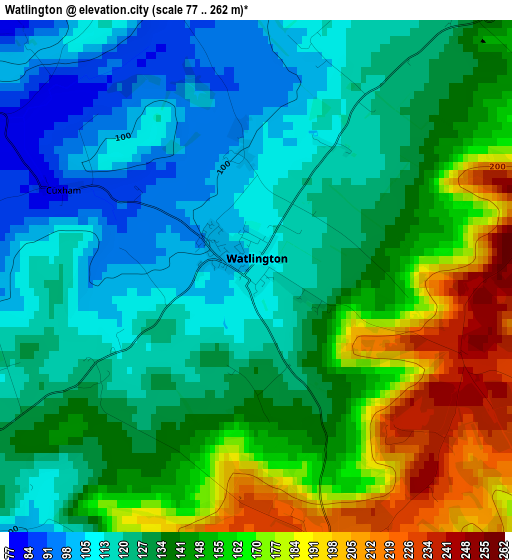
Below is the Elevation map of Watlington, which displays elevation range with different colors. Scale of the first map is from 77 to 262 m (253 to 860 ft) with average elevation of 138 meters (=453 ft) [note 1]
These maps also provides idea of topography and contour of this city, they are displayed at different zoom levels. More info about maps, scale and edge coordinates you can find below images.
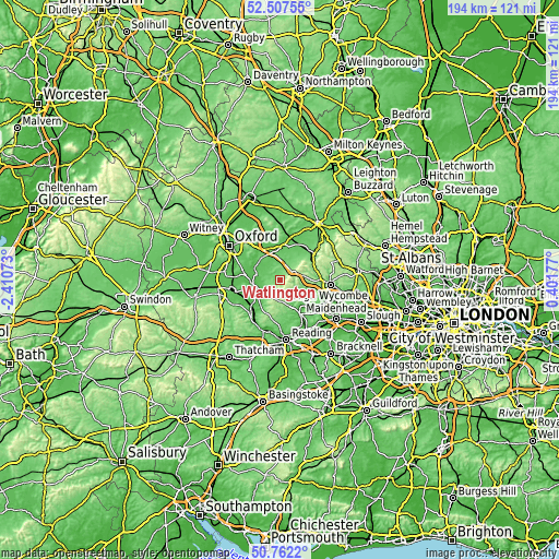
| \ | Map #1 | Topo.Map |
| Scale [m] | 77..262 m | × |
| Scale [ft] | 253..860 ft | × |
| Average | 138 m = 453 ft | × |
| Width | 6.06 km = 3.8 mi | 194.1 km = 120.6 mi |
| Height | 6.06 km = 3.8 mi | 194 km = 120.5 mi |
| ↑Max Latitude | 51.670532° | 52.50755° |
| Latitude at center | 51.64327° | 51.64327° |
| ↓Min Latitude | 51.615991° | 50.7622° |
| ← Min Longitude | -1.048425° | -2.41073° |
| Longitude center | -1.00448° | -1.00448° |
| →Max Longitude | -0.960535° | 0.40177° |
Nearby cities:
Cities around Watlington sort by population:
• Henley-on-Thames elevation 34 m
14.2 km,  149°
149°
• Thame 72 m
11.9 km,  9°
9°
• Wallingford 51 m
9.6 km,  239°
239°
• Benson 52 m
7.7 km,  250°
250°
• Chinnor 120 m
9.1 km,  44°
44°
• Sonning Common 87 m
14 km,  172°
172°
• Stokenchurch 223 m
7.6 km,  77°
77°
• Cholsey 48 m
12.9 km,  232°
232°
• Chalgrove 68 m
5.5 km,  295°
295°
• Rotherfield Peppard 104 m
12.7 km, 171°
• Garsington 109 m
13.5 km,  306°
306°
• Remenham 34 m
12.8 km,  142°
142°
Multilingual:
 En español:
Watlington elevación 109 m.
 En France:
Watlington élévation 109 m.
 Auf Deutsch:
Watlington höhe über dem Meeresspiegel ist 109 m.

Sources and notes:
- [note 1] Map square and city borders are not equal. Map elevation data is calculated only from area inside that square.
- [src 1] Elevation data from geonames database provided with same terms of usage.
- [src 2] The elevation map of Watlington is generated using elevation data from NASA's 3 arcsec (90m) resolution SRTM data.
- [src 3] Base (background) map © OpenStreetMap contributors tiles are generated by Geofabrik and OpenTopoMap.
Copyright & License:
This Watlington Elevation Map is licensed under CC BY-SA. You may reuse any part from this page, if you give a proper credit by linking to this URL:
 More info on terms of use page.