Gabon elevation
On our site we have elevation data and maps for 27 cities from Gabon including Libreville as capital of the country.
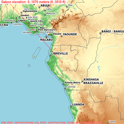
Gabon on topographic map
Gabon elevation extremes
Land surface elevation extremes in Gabon:
- Highest point in Gabon: Mont Bengoué with 1070 meters (=3510 ft)
- Lowest point: Atlantic Ocean with 0 meters (=0 ft)
- Elevation span: 1070 m (=3510 ft)
Statistics
- Main average elevation: 377 meters (= 1237 ft)
- Average elevation of cities: 257 m (= 843 ft), and this is 139 m (456 ft) below average city elevation worldwide..[1]
- Area: 267,667 km² (= 103,347 sq mi)
- Population: 1,545,255


List of cities in ABC order:
Search by letter:
B C F G K L M N O P T
B:
Bitam Booué
C:
Cocobeach
F:
Fougamou Franceville
G:
Gamba
K:
Koulamoutou
L:
Lambaréné Lastoursville Lékoni Libreville
M:
Makokou Mayumba Mbigou Mimongo Mitzic Moanda Mouila Mounana
N:
Ndendé Ndjolé Ntoum
O:
Okondja Omboué Oyem
P:
Port-Gentil
T:
Tchibanga
5 most populated cities are in red/bold font style.

B:
Bitam Booué
C:
Cocobeach
F:
Fougamou Franceville
G:
Gamba
K:
Koulamoutou
L:
Lambaréné Lastoursville Lékoni Libreville
M:
Makokou Mayumba Mbigou Mimongo Mitzic Moanda Mouila Mounana
N:
Ndendé Ndjolé Ntoum
O:
Okondja Omboué Oyem
P:
Port-Gentil
T:
Tchibanga
Sources
- Elevation extremes by country from wikipedia.
- Base map data: © OpenStreetMap contributors, | map style: © OpenTopoMap (CC-BY-SA)
- [1] Calculated only from 27 cities in our database
- Other city data from geonames.org with taken over terms of usage.
- Min/max latitude and longitude coordinates per country from latitudelongitude.org website.