Franceville elevation
Franceville (Haut-Ogooué), Gabon elevation is 405 meters and Franceville elevation in feet is 1329 ft above sea level [src 1]. Franceville is a seat of a first-order administrative division (feature code) with elevation that is 148 meters (486 ft) bigger than average city elevation in Gabon.
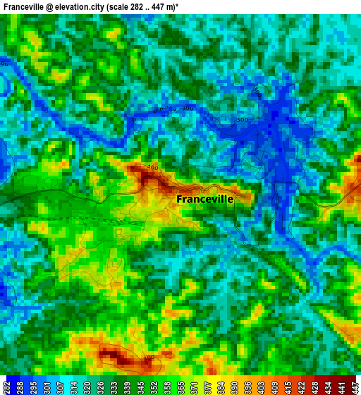
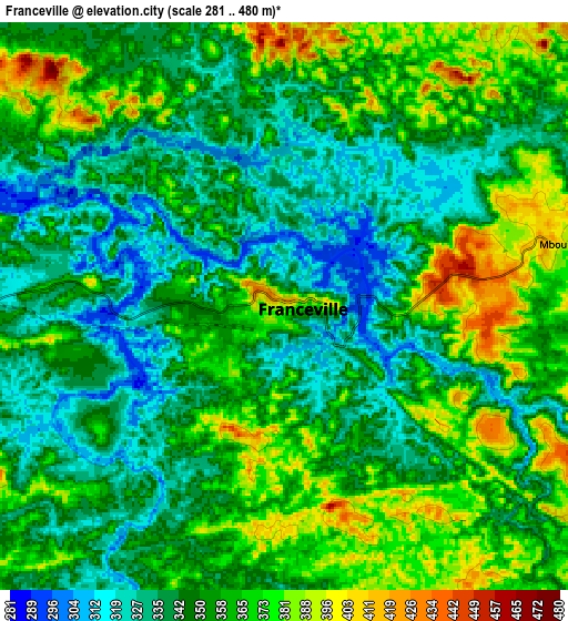
Below is the Elevation map of Franceville, which displays elevation range with different colors. Scale of the first map is from 282 to 447 m (925 to 1467 ft) with average elevation of 336 meters (=1102 ft) [note 1]
These maps also provides idea of topography and contour of this city, they are displayed at different zoom levels. More info about maps, scale and edge coordinates you can find below images.
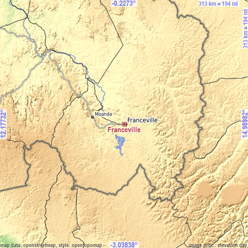
| \ | Map #1 | Map #2 | Topo.Map |
| Scale [m] | 282..447 m | 281..480 m | × |
| Scale [ft] | 925..1467 ft | 922..1575 ft | × |
| Average | 336 m = 1102 ft | 353.1 m = 1158 ft | × |
| Width | 9.77 km = 6.1 mi | 19.54 km = 12.1 mi | 312.6 km = 194.2 mi |
| Height | 9.77 km = 6.1 mi | 19.54 km = 12.1 mi | 312.6 km = 194.2 mi |
| ↑Max Latitude | -1.589402° | -1.545473° | -0.2273° |
| Latitude at center | -1.63333° | -1.63333° | -1.63333° |
| ↓Min Latitude | -1.677257° | -1.721183° | -3.03838° |
| ← Min Longitude | 13.539625° | 13.495679° | 12.17732° |
| Longitude center | 13.58357° | 13.58357° | 13.58357° |
| →Max Longitude | 13.627515° | 13.671461° | 14.98982° |
Nearby cities:
Cities around Franceville sort by population:
• Moanda elevation 416 m
43.4 km,  279°
279°
• Mouila 92 m
282.1 km,  264°
264°
• Koulamoutou 282 m
136.2 km,  293°
293°
• Makokou 489 m
258.1 km,  341°
341°
• Mounana 459 m
53.4 km,  297°
297°
• Lastoursville 251 m
133 km,  312°
312°
• Okondja 347 m
109.3 km,  5°
5°
• Ndendé 130 m
261.6 km,  250°
250°
• Booué 217 m
250.6 km, 313°
• Mbigou 667 m
188.8 km, 260°
• Lékoni 502 m
75.3 km,  85°
85°
• Mimongo 539 m
219.7 km,  270°
270°
Multilingual:
 En español:
Franceville elevación 405 m.
 En France:
Franceville élévation 405 m.
 Auf Deutsch:
Franceville höhe über dem Meeresspiegel ist 405 m.

Sources and notes:
- [note 1] Map square and city borders are not equal. Map elevation data is calculated only from area inside that square.
- [src 1] Elevation data from geonames database provided with same terms of usage.
- [src 2] The elevation map of Franceville is generated using elevation data from NASA's 3 arcsec (90m) resolution SRTM data.
- [src 3] Base (background) map © OpenStreetMap contributors tiles are generated by Geofabrik and OpenTopoMap.
Copyright & License:
This Franceville Elevation Map is licensed under CC BY-SA. You may reuse any part from this page, if you give a proper credit by linking to this URL:
 More info on terms of use page.