Libreville elevation
Libreville (Estuaire), Gabon elevation is 8 meters and Libreville elevation in feet is 26 ft above sea level [src 1]. Libreville is a capital of a political entity (feature code) with elevation that is 249 meters (817 ft) smaller than average city elevation in Gabon.
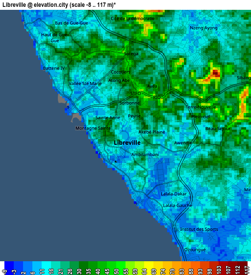
Below is the Elevation map of Libreville, which displays elevation range with different colors. Scale of the first map is from -8 to 117 m (-26 to 384 ft) with average elevation of 21.5 meters (=71 ft) [note 1]
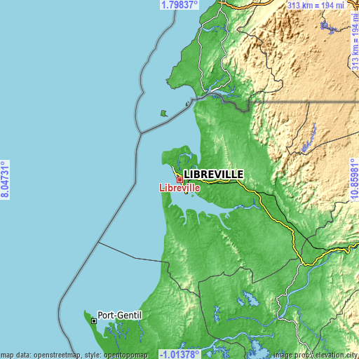
These maps also provides idea of topography and contour of this city, they are displayed at different zoom levels. More info about maps, scale and edge coordinates you can find below images.
| \ | Map #1 | Map #2 | Topo.Map |
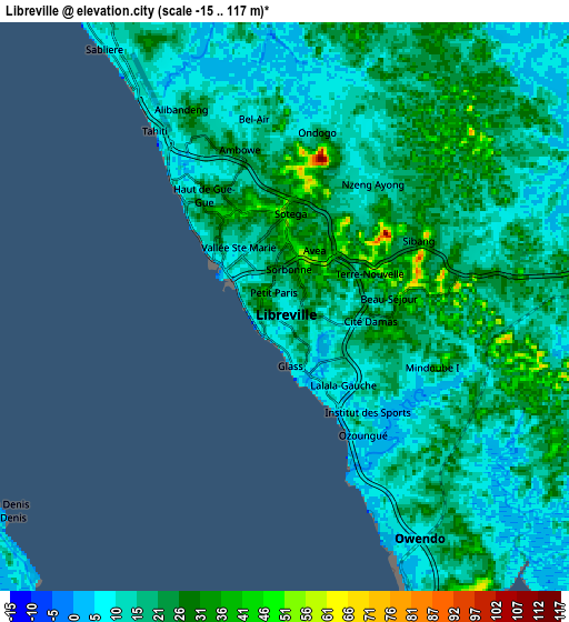
| Scale [m] | -8..117 m | -15..117 m | × |
| Scale [ft] | -26..384 ft | -49..384 ft | × |
| Average | 21.5 m = 71 ft | 18.2 m = 60 ft | × |
| Width | 9.77 km = 6.1 mi | 19.54 km = 12.1 mi | 312.7 km = 194.3 mi |
| Height | 9.77 km = 6.1 mi | 19.54 km = 12.1 mi | 312.7 km = 194.3 mi |
| ↑Max Latitude | 0.436354° | 0.480298° | 1.79837° |
| Latitude at center | 0.39241° | 0.39241° | 0.39241° |
| ↓Min Latitude | 0.348466° | 0.304521° | -1.01378° |
| ← Min Longitude | 9.409615° | 9.365669° | 8.04731° |
| Longitude center | 9.45356° | 9.45356° | 9.45356° |
| →Max Longitude | 9.497505° | 9.541451° | 10.85981° |
Nearby cities:
Cities around Libreville sort by population:
• Port-Gentil elevation 4 m
144.4 km,  211°
211°
• Oyem 656 m
271.8 km,  60°
60°
• Mouila 92 m
308.1 km,  144°
144°
• Lambaréné 26 m
149.7 km, 144°
• Bitam 575 m
294.7 km,  50°
50°
• Ntoum 11 m
34.2 km,  90°
90°
• Booué 217 m
281.5 km,  101°
101°
• Fougamou 93 m
218.5 km, 144°
• Ndjolé 53 m
159 km,  113°
113°
• Mitzic 583 m
237 km,  79°
79°
• Omboué 8 m
219.8 km,  185°
185°
• Cocobeach 18 m
69.1 km,  11°
11°
Multilingual:
 En español:
Libreville elevación 8 m.
 En France:
Libreville élévation 8 m.
 Auf Deutsch:
Libreville höhe über dem Meeresspiegel ist 8 m.

Sources and notes:
- [note 1] Map square and city borders are not equal. Map elevation data is calculated only from area inside that square.
- [src 1] Elevation data from geonames database provided with same terms of usage.
- [src 2] The elevation map of Libreville is generated using elevation data from NASA's 3 arcsec (90m) resolution SRTM data.
- [src 3] Base (background) map © OpenStreetMap contributors tiles are generated by Geofabrik and OpenTopoMap.
Copyright & License:
This Libreville Elevation Map is licensed under CC BY-SA. You may reuse any part from this page, if you give a proper credit by linking to this URL:
 More info on terms of use page.