Mayumba elevation
Mayumba (Nyanga), Gabon elevation is 17 meters and Mayumba elevation in feet is 56 ft above sea level [src 1]. Mayumba is a populated place (feature code) with elevation that is 240 meters (787 ft) smaller than average city elevation in Gabon.
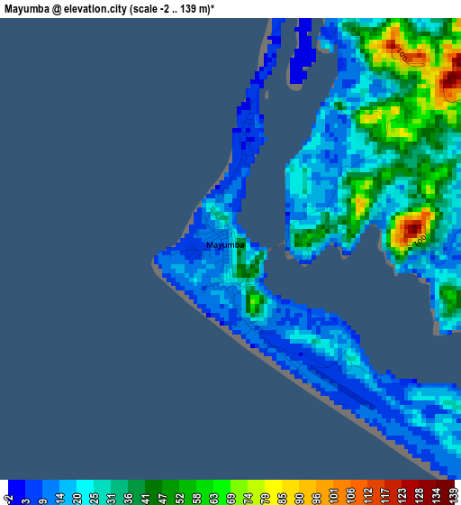
Below is the Elevation map of Mayumba, which displays elevation range with different colors. Scale of the first map is from -2 to 139 m (-7 to 456 ft) with average elevation of 28.3 meters (=93 ft) [note 1]
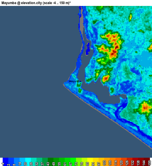
These maps also provides idea of topography and contour of this city, they are displayed at different zoom levels. More info about maps, scale and edge coordinates you can find below images.
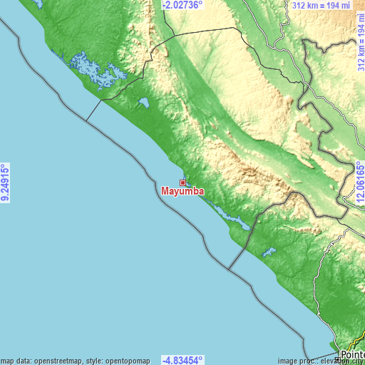
| \ | Map #1 | Map #2 | Topo.Map |
| Scale [m] | -2..139 m | -4..150 m | × |
| Scale [ft] | -7..456 ft | -13..492 ft | × |
| Average | 28.3 m = 93 ft | 26.4 m = 87 ft | × |
| Width | 9.75 km = 6.1 mi | 19.51 km = 12.1 mi | 312.1 km = 193.9 mi |
| Height | 9.75 km = 6.1 mi | 19.51 km = 12.1 mi | 312.2 km = 194 mi |
| ↑Max Latitude | -3.388112° | -3.344243° | -2.02736° |
| Latitude at center | -3.43198° | -3.43198° | -3.43198° |
| ↓Min Latitude | -3.475845° | -3.519709° | -4.83454° |
| ← Min Longitude | 10.611455° | 10.567509° | 9.24915° |
| Longitude center | 10.6554° | 10.6554° | 10.6554° |
| →Max Longitude | 10.699345° | 10.743291° | 12.06165° |
Nearby cities:
Cities around Mayumba sort by population:
• Moanda elevation 416 m
350.5 km,  53°
53°
• Mouila 92 m
179.4 km,  14°
14°
• Lambaréné 26 m
307.2 km,  351°
351°
• Tchibanga 49 m
66.2 km,  33°
33°
• Koulamoutou 282 m
324.8 km,  38°
38°
• Gamba 43 m
113.4 km,  320°
320°
• Mounana 459 m
357.7 km, 51°
• Ndendé 130 m
138.7 km, 34°
• Fougamou 93 m
246.6 km,  358°
358°
• Mbigou 667 m
219.8 km, 39°
• Mimongo 539 m
227.6 km, 27°
• Omboué 8 m
258.1 km, 323°
Multilingual:
 En español:
Mayumba elevación 17 m.
 En France:
Mayumba élévation 17 m.


Sources and notes:
- [note 1] Map square and city borders are not equal. Map elevation data is calculated only from area inside that square.
- [src 1] Elevation data from geonames database provided with same terms of usage.
- [src 2] The elevation map of Mayumba is generated using elevation data from NASA's 3 arcsec (90m) resolution SRTM data.
- [src 3] Base (background) map © OpenStreetMap contributors tiles are generated by Geofabrik and OpenTopoMap.
Copyright & License:
This Mayumba Elevation Map is licensed under CC BY-SA. You may reuse any part from this page, if you give a proper credit by linking to this URL:
 More info on terms of use page.