Annot elevation
Annot (Provence-Alpes-Côte d'Azur, Alpes-de-Haute-Provence), France elevation is 857 meters and Annot elevation in feet is 2812 ft above sea level [src 1]. Annot is a populated place (feature code) with elevation that is 683 meters (2241 ft) bigger than average city elevation in France.
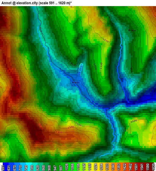
Below is the Elevation map of Annot, which displays elevation range with different colors. Scale of the first map is from 591 to 1620 m (1939 to 5315 ft) with average elevation of 1041.1 meters (=3416 ft) [note 1]
These maps also provides idea of topography and contour of this city, they are displayed at different zoom levels. More info about maps, scale and edge coordinates you can find below images.
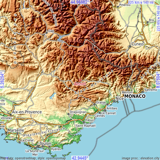
| \ | Map #1 | Topo.Map |
| Scale [m] | 591..1620 m | × |
| Scale [ft] | 1939..5315 ft | × |
| Average | 1041.1 m = 3416 ft | × |
| Width | 7.03 km = 4.4 mi | 225.1 km = 139.9 mi |
| Height | 7.03 km = 4.4 mi | 225.1 km = 139.9 mi |
| ↑Max Latitude | 43.996902° | 44.96882° |
| Latitude at center | 43.96528° | 43.96528° |
| ↓Min Latitude | 43.933641° | 42.9445° |
| ← Min Longitude | 6.624845° | 5.26254° |
| Longitude center | 6.66879° | 6.66879° |
| →Max Longitude | 6.712735° | 8.07504° |
Nearby cities:
Cities around Annot sort by population:
• Digne-les-Bains elevation 596 m
37.7 km,  292°
292°
• Fayence 375 m
37.8 km,  176°
176°
• Saint-Cézaire-sur-Siagne 448 m
36.4 km,  164°
164°
• Callian 310 m
38.7 km,  169°
169°
• Saint-Vallier-de-Thiey 720 m
33 km,  154°
154°
• Seillans 380 m
36.6 km, 183°
• Puget-Théniers 427 m
18 km,  93°
93°
• Castellane 806 m
18.1 km,  223°
223°
• Cabris 410 m
38.1 km, 154°
• Saint-Étienne-de-Tinée 1140 m
38.3 km,  32°
32°
• Spéracèdes 240 m
38.4 km, 156°
• Le Brusquet 818 m
36.1 km,  307°
307°
Multilingual:
 En español:
Annot elevación 857 m.
 En France:
Annot élévation 857 m.


Sources and notes:
- [note 1] Map square and city borders are not equal. Map elevation data is calculated only from area inside that square.
- [src 1] Elevation data from geonames database provided with same terms of usage.
- [src 2] The elevation map of Annot is generated using elevation data from NASA's 3 arcsec (90m) resolution SRTM data.
- [src 3] Base (background) map © OpenStreetMap contributors tiles are generated by Geofabrik and OpenTopoMap.
Copyright & License:
This Annot Elevation Map is licensed under CC BY-SA. You may reuse any part from this page, if you give a proper credit by linking to this URL:
 More info on terms of use page.