Saint-Étienne-de-Tinée elevation
Saint-Étienne-de-Tinée (Provence-Alpes-Côte d'Azur, Alpes-Maritimes), France elevation is 1140 meters and Saint-Étienne-de-Tinée elevation in feet is 3740 ft above sea level [src 1]. Saint-Étienne-de-Tinée is a populated place (feature code) with elevation that is 966 meters (3169 ft) bigger than average city elevation in France.
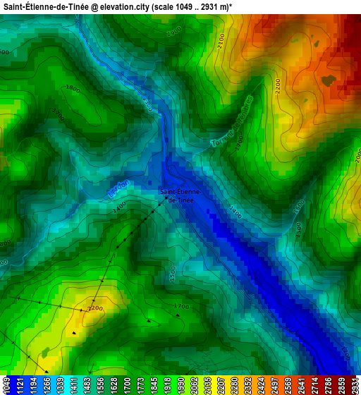
Below is the Elevation map of Saint-Étienne-de-Tinée, which displays elevation range with different colors. Scale of the first map is from 1049 to 2931 m (3442 to 9616 ft) with average elevation of 1706.1 meters (=5597 ft) [note 1]
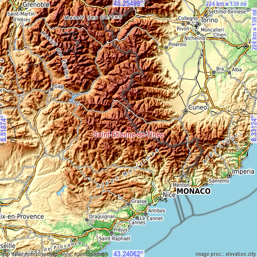
These maps also provides idea of topography and contour of this city, they are displayed at different zoom levels. More info about maps, scale and edge coordinates you can find below images.
| \ | Map #1 | Topo.Map |
| Scale [m] | 1049..2931 m | × |
| Scale [ft] | 3442..9616 ft | × |
| Average | 1706.1 m = 5597 ft | × |
| Width | 7 km = 4.3 mi | 224 km = 139.2 mi |
| Height | 7 km = 4.3 mi | 224 km = 139.2 mi |
| ↑Max Latitude | 44.287896° | 45.25499° |
| Latitude at center | 44.25643° | 44.25643° |
| ↓Min Latitude | 44.224947° | 43.24062° |
| ← Min Longitude | 6.881045° | 5.51874° |
| Longitude center | 6.92499° | 6.92499° |
| →Max Longitude | 6.968935° | 8.33124° |
Nearby cities:
Cities around Saint-Étienne-de-Tinée sort by population:
• Embrun elevation 869 m
48.3 km,  315°
315°
• Barcelonnette 1141 m
26.1 km,  303°
303°
• Guillestre 1003 m
49.9 km,  333°
333°
• Puget-Théniers 427 m
33.5 km,  184°
184°
• Roquebillière 616 m
40.9 km,  131°
131°
• Seyne-les-Alpes 1189 m
46.4 km,  283°
283°
• Saint-Martin-Vésubie 1076 m
33.6 km, 128°
• Gilette 417 m
49.1 km,  157°
157°
• Annot 857 m
38.3 km,  212°
212°
• Lantosque 477 m
44 km,  135°
135°
• Jausiers 1214 m
23.7 km, 318°
• Le Brusquet 818 m
50.2 km,  257°
257°
Multilingual:
 En español:
Saint-Étienne-de-Tinée elevación 1140 m.
 En France:
Saint-Étienne-de-Tinée élévation 1140 m.
 Auf Deutsch:
Saint-Étienne-de-Tinée höhe über dem Meeresspiegel ist 1140 m.
 На русском:
Сент-Этьен-де-Тине высота над уровнем моря 1140 м
Sources and notes:
- [note 1] Map square and city borders are not equal. Map elevation data is calculated only from area inside that square.
- [src 1] Elevation data from geonames database provided with same terms of usage.
- [src 2] The elevation map of Saint-Étienne-de-Tinée is generated using elevation data from NASA's 3 arcsec (90m) resolution SRTM data.
- [src 3] Base (background) map © OpenStreetMap contributors tiles are generated by Geofabrik and OpenTopoMap.
Copyright & License:
This Saint-Étienne-de-Tinée Elevation Map is licensed under CC BY-SA. You may reuse any part from this page, if you give a proper credit by linking to this URL:
 More info on terms of use page.