Embrun elevation
Embrun (Provence-Alpes-Côte d'Azur, Hautes-Alpes), France elevation is 869 meters and Embrun elevation in feet is 2851 ft above sea level [src 1]. Embrun is a populated place (feature code) with elevation that is 695 meters (2280 ft) bigger than average city elevation in France.
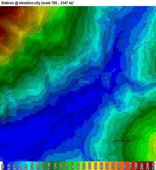
Below is the Elevation map of Embrun, which displays elevation range with different colors. Scale of the first map is from 765 to 2147 m (2510 to 7044 ft) with average elevation of 1054.5 meters (=3460 ft) [note 1]
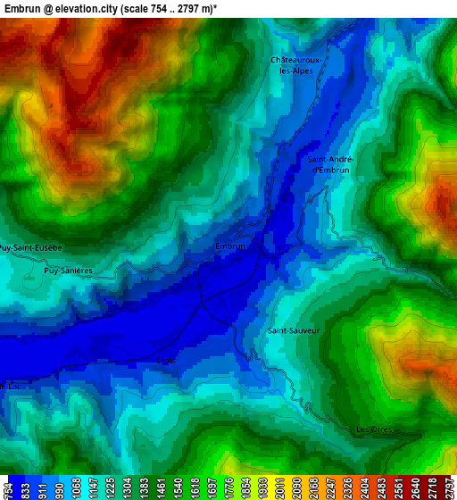
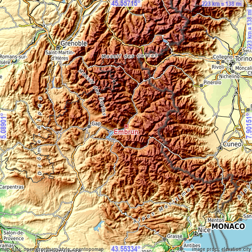
These maps also provides idea of topography and contour of this city, they are displayed at different zoom levels. More info about maps, scale and edge coordinates you can find below images.
| \ | Map #1 | Map #2 | Topo.Map |
| Scale [m] | 765..2147 m | 754..2797 m | × |
| Scale [ft] | 2510..7044 ft | 2474..9177 ft | × |
| Average | 1054.5 m = 3460 ft | 1387.7 m = 4553 ft | × |
| Width | 6.96 km = 4.3 mi | 13.93 km = 8.7 mi | 222.8 km = 138.4 mi |
| Height | 6.96 km = 4.3 mi | 13.93 km = 8.7 mi | 222.8 km = 138.4 mi |
| ↑Max Latitude | 44.595171° | 44.626456° | 45.55715° |
| Latitude at center | 44.56387° | 44.56387° | 44.56387° |
| ↓Min Latitude | 44.532552° | 44.501217° | 43.55334° |
| ← Min Longitude | 6.451315° | 6.407369° | 5.08901° |
| Longitude center | 6.49526° | 6.49526° | 6.49526° |
| →Max Longitude | 6.539205° | 6.583151° | 7.90151° |
Nearby cities:
Cities around Embrun sort by population:
• Gap elevation 743 m
33 km,  268°
268°
• Briançon 1301 m
39.1 km,  17°
17°
• Barcelonnette 1141 m
23.3 km,  147°
147°
• Guillestre 1003 m
16.2 km,  48°
48°
• Chorges 919 m
17.4 km,  264°
264°
• Tallard 603 m
36.9 km,  252°
252°
• La Bâtie-Neuve 910 m
23.7 km, 270°
• Saint-Bonnet-en-Champsaur 1064 m
35.2 km,  292°
292°
• Villar-Saint-Pancrace 1236 m
35.9 km, 16°
• Seyne-les-Alpes 1189 m
26.2 km,  204°
204°
• Jausiers 1214 m
24.7 km,  131°
131°
• Saint-Martin-de-Queyrières 1224 m
29.6 km,  12°
12°
Multilingual:
 En español:
Embrun elevación 869 m.
 En France:
Embrun élévation 869 m.


Sources and notes:
- [note 1] Map square and city borders are not equal. Map elevation data is calculated only from area inside that square.
- [src 1] Elevation data from geonames database provided with same terms of usage.
- [src 2] The elevation map of Embrun is generated using elevation data from NASA's 3 arcsec (90m) resolution SRTM data.
- [src 3] Base (background) map © OpenStreetMap contributors tiles are generated by Geofabrik and OpenTopoMap.
Copyright & License:
This Embrun Elevation Map is licensed under CC BY-SA. You may reuse any part from this page, if you give a proper credit by linking to this URL:
 More info on terms of use page.