Saint-Vallier-de-Thiey elevation
Saint-Vallier-de-Thiey (Provence-Alpes-Côte d'Azur, Alpes-Maritimes), France elevation is 720 meters and Saint-Vallier-de-Thiey elevation in feet is 2362 ft above sea level [src 1]. Saint-Vallier-de-Thiey is a populated place (feature code) with elevation that is 546 meters (1791 ft) bigger than average city elevation in France.
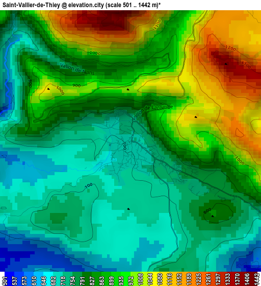
Below is the Elevation map of Saint-Vallier-de-Thiey, which displays elevation range with different colors. Scale of the first map is from 501 to 1442 m (1644 to 4731 ft) with average elevation of 841.6 meters (=2761 ft) [note 1]
These maps also provides idea of topography and contour of this city, they are displayed at different zoom levels. More info about maps, scale and edge coordinates you can find below images.
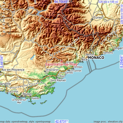
| \ | Map #1 | Topo.Map |
| Scale [m] | 501..1442 m | × |
| Scale [ft] | 1644..4731 ft | × |
| Average | 841.6 m = 2761 ft | × |
| Width | 7.07 km = 4.4 mi | 226.1 km = 140.5 mi |
| Height | 7.07 km = 4.4 mi | 226.1 km = 140.5 mi |
| ↑Max Latitude | 43.730173° | 44.70649° |
| Latitude at center | 43.69841° | 43.69841° |
| ↓Min Latitude | 43.66663° | 42.6731° |
| ← Min Longitude | 6.803845° | 5.44154° |
| Longitude center | 6.84779° | 6.84779° |
| →Max Longitude | 6.891735° | 8.25404° |
Nearby cities:
Cities around Saint-Vallier-de-Thiey sort by population:
• Grasse elevation 194 m
7.7 km,  125°
125°
• Peymeinade 213 m
6.6 km,  160°
160°
• Montauroux 380 m
11.1 km,  216°
216°
• Saint-Cézaire-sur-Siagne 448 m
7 km, 219°
• Châteauneuf-Grasse 258 m
11.5 km,  107°
107°
• Le Tignet 257 m
6.5 km,  181°
181°
• Le Bar-sur-Loup 385 m
10.9 km,  89°
89°
• Auribeau-sur-Siagne 57 m
12 km, 155°
• Callian 310 m
11.4 km, 222°
• Opio 294 m
11.3 km, 107°
• Cabris 410 m
5.1 km, 156°
• Spéracèdes 240 m
5.6 km,  170°
170°
Multilingual:
 En español:
Saint-Vallier-de-Thiey elevación 720 m.
 En France:
Saint-Vallier-de-Thiey élévation 720 m.
 Auf Deutsch:
Saint-Vallier-de-Thiey höhe über dem Meeresspiegel ist 720 m.
 На русском:
Saint-Vallier-de-Thiey высота над уровнем моря 720 м
Sources and notes:
- [note 1] Map square and city borders are not equal. Map elevation data is calculated only from area inside that square.
- [src 1] Elevation data from geonames database provided with same terms of usage.
- [src 2] The elevation map of Saint-Vallier-de-Thiey is generated using elevation data from NASA's 3 arcsec (90m) resolution SRTM data.
- [src 3] Base (background) map © OpenStreetMap contributors tiles are generated by Geofabrik and OpenTopoMap.
Copyright & License:
This Saint-Vallier-de-Thiey Elevation Map is licensed under CC BY-SA. You may reuse any part from this page, if you give a proper credit by linking to this URL:
 More info on terms of use page.