Apt elevation
Apt (Provence-Alpes-Côte d'Azur, Département du Vaucluse), France elevation is 243 meters and Apt elevation in feet is 797 ft above sea level [src 1]. Apt is a seat of a third-order administrative division (feature code) with elevation that is 69 meters (226 ft) bigger than average city elevation in France.
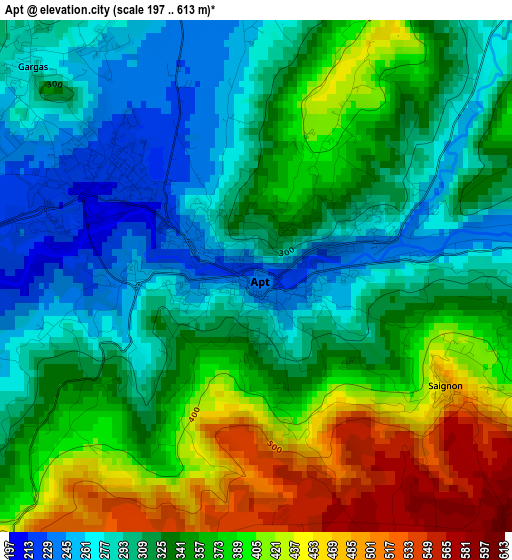
Below is the Elevation map of Apt, which displays elevation range with different colors. Scale of the first map is from 197 to 613 m (646 to 2011 ft) with average elevation of 344 meters (=1129 ft) [note 1]
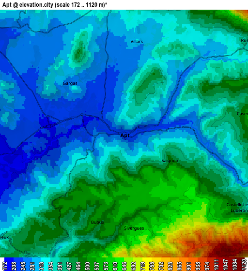
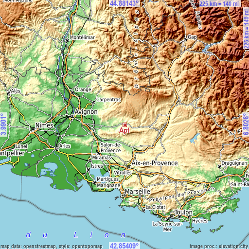
These maps also provides idea of topography and contour of this city, they are displayed at different zoom levels. More info about maps, scale and edge coordinates you can find below images.
| \ | Map #1 | Map #2 | Topo.Map |
| Scale [m] | 197..613 m | 172..1120 m | × |
| Scale [ft] | 646..2011 ft | 564..3675 ft | × |
| Average | 344 m = 1129 ft | 388 m = 1273 ft | × |
| Width | 7.04 km = 4.4 mi | 14.09 km = 8.8 mi | 225.4 km = 140.1 mi |
| Height | 7.04 km = 4.4 mi | 14.09 km = 8.8 mi | 225.4 km = 140.1 mi |
| ↑Max Latitude | 43.908049° | 43.939701° | 44.88143° |
| Latitude at center | 43.87638° | 43.87638° | 43.87638° |
| ↓Min Latitude | 43.844694° | 43.812992° | 42.85409° |
| ← Min Longitude | 5.352405° | 5.308459° | 3.9901° |
| Longitude center | 5.39635° | 5.39635° | 5.39635° |
| →Max Longitude | 5.440295° | 5.484241° | 6.8026° |
Nearby cities:
Cities around Apt sort by population:
• Cadenet elevation 208 m
15.8 km,  186°
186°
• Lauris 190 m
15.8 km,  204°
204°
• Gargas 279 m
4.2 km,  312°
312°
• Saint-Saturnin-lès-Apt 298 m
6.4 km,  350°
350°
• Cucuron 352 m
12 km,  163°
163°
• Goult 217 m
12.3 km,  263°
263°
• Bonnieux 351 m
9.2 km,  230°
230°
• Roussillon 282 m
8.8 km,  289°
289°
• Céreste 397 m
15.4 km,  98°
98°
• Lourmarin 235 m
12.8 km, 192°
• Ménerbes 237 m
16 km,  252°
252°
• Saignon 430 m
3 km,  119°
119°
Multilingual:
 En español:
Apt elevación 243 m.
 En France:
Apt élévation 243 m.


Sources and notes:
- [note 1] Map square and city borders are not equal. Map elevation data is calculated only from area inside that square.
- [src 1] Elevation data from geonames database provided with same terms of usage.
- [src 2] The elevation map of Apt is generated using elevation data from NASA's 3 arcsec (90m) resolution SRTM data.
- [src 3] Base (background) map © OpenStreetMap contributors tiles are generated by Geofabrik and OpenTopoMap.
Copyright & License:
This Apt Elevation Map is licensed under CC BY-SA. You may reuse any part from this page, if you give a proper credit by linking to this URL:
 More info on terms of use page.