Lourmarin elevation
Lourmarin (Provence-Alpes-Côte d'Azur, Département du Vaucluse), France elevation is 235 meters and Lourmarin elevation in feet is 771 ft above sea level [src 1]. Lourmarin is a populated place (feature code) with elevation that is 61 meters (200 ft) bigger than average city elevation in France.
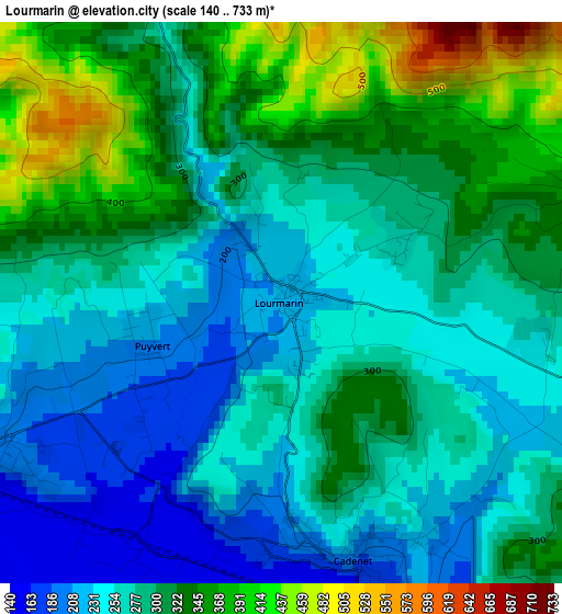
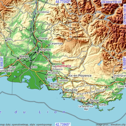
Below is the Elevation map of Lourmarin, which displays elevation range with different colors. Scale of the first map is from 140 to 733 m (459 to 2405 ft) with average elevation of 290.9 meters (=954 ft) [note 1]
These maps also provides idea of topography and contour of this city, they are displayed at different zoom levels. More info about maps, scale and edge coordinates you can find below images.
| \ | Map #1 | Topo.Map |
| Scale [m] | 140..733 m | × |
| Scale [ft] | 459..2405 ft | × |
| Average | 290.9 m = 954 ft | × |
| Width | 7.06 km = 4.4 mi | 225.8 km = 140.3 mi |
| Height | 7.06 km = 4.4 mi | 225.8 km = 140.3 mi |
| ↑Max Latitude | 43.795579° | 44.77082° |
| Latitude at center | 43.76385° | 43.76385° |
| ↓Min Latitude | 43.732104° | 42.73965° |
| ← Min Longitude | 5.318695° | 3.95639° |
| Longitude center | 5.36264° | 5.36264° |
| →Max Longitude | 5.406585° | 6.76889° |
Nearby cities:
Cities around Lourmarin sort by population:
• Apt elevation 243 m
12.8 km,  12°
12°
• La Roque-d’Anthéron 168 m
6.9 km,  218°
218°
• Le Puy-Sainte-Réparade 204 m
12.5 km,  152°
152°
• Rognes 316 m
11.2 km,  186°
186°
• Cadenet 208 m
3.3 km,  164°
164°
• Lauris 190 m
4.4 km,  244°
244°
• Villelaure 252 m
8.2 km,  135°
135°
• Charleval 151 m
10.7 km, 241°
• Cucuron 352 m
6.2 km,  80°
80°
• Bonnieux 351 m
8 km,  326°
326°
• Ansouis 265 m
8.6 km,  109°
109°
• Saignon 430 m
12.2 km,  25°
25°
Multilingual:
 En español:
Lourmarin elevación 235 m.
 En France:
Lourmarin élévation 235 m.
 Auf Deutsch:
Lourmarin höhe über dem Meeresspiegel ist 235 m.

Sources and notes:
- [note 1] Map square and city borders are not equal. Map elevation data is calculated only from area inside that square.
- [src 1] Elevation data from geonames database provided with same terms of usage.
- [src 2] The elevation map of Lourmarin is generated using elevation data from NASA's 3 arcsec (90m) resolution SRTM data.
- [src 3] Base (background) map © OpenStreetMap contributors tiles are generated by Geofabrik and OpenTopoMap.
Copyright & License:
This Lourmarin Elevation Map is licensed under CC BY-SA. You may reuse any part from this page, if you give a proper credit by linking to this URL:
 More info on terms of use page.