Saint-Saturnin-lès-Apt elevation
Saint-Saturnin-lès-Apt (Provence-Alpes-Côte d'Azur, Département du Vaucluse), France elevation is 298 meters and Saint-Saturnin-lès-Apt elevation in feet is 978 ft above sea level [src 1]. Saint-Saturnin-lès-Apt is a populated place (feature code) with elevation that is 124 meters (407 ft) bigger than average city elevation in France.
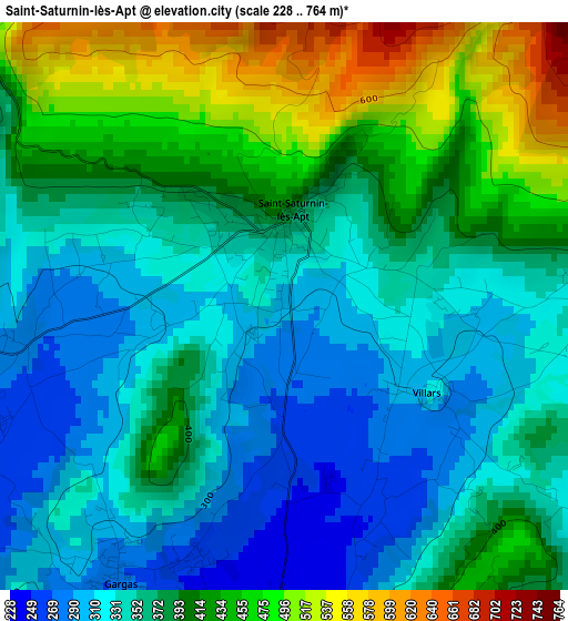
Below is the Elevation map of Saint-Saturnin-lès-Apt, which displays elevation range with different colors. Scale of the first map is from 228 to 764 m (748 to 2507 ft) with average elevation of 378.5 meters (=1242 ft) [note 1]
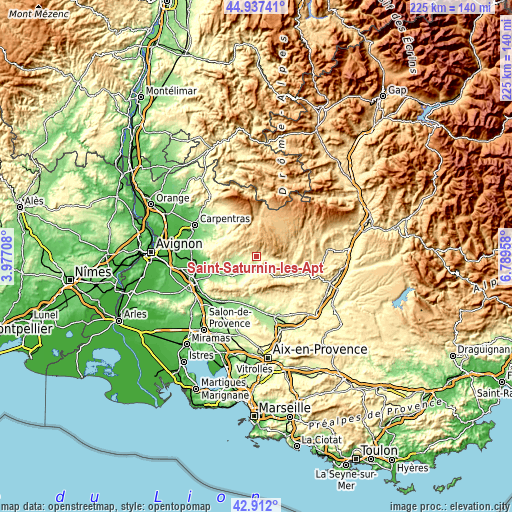
These maps also provides idea of topography and contour of this city, they are displayed at different zoom levels. More info about maps, scale and edge coordinates you can find below images.
| \ | Map #1 | Topo.Map |
| Scale [m] | 228..764 m | × |
| Scale [ft] | 748..2507 ft | × |
| Average | 378.5 m = 1242 ft | × |
| Width | 7.04 km = 4.4 mi | 225.2 km = 139.9 mi |
| Height | 7.04 km = 4.4 mi | 225.2 km = 139.9 mi |
| ↑Max Latitude | 43.964969° | 44.93741° |
| Latitude at center | 43.93333° | 43.93333° |
| ↓Min Latitude | 43.901674° | 42.912° |
| ← Min Longitude | 5.339385° | 3.97708° |
| Longitude center | 5.38333° | 5.38333° |
| →Max Longitude | 5.427275° | 6.78958° |
Nearby cities:
Cities around Saint-Saturnin-lès-Apt sort by population:
• Apt elevation 243 m
6.4 km,  170°
170°
• Gargas 279 m
4 km,  210°
210°
• Gordes 296 m
14.9 km,  261°
261°
• Cucuron 352 m
18.4 km, 166°
• Goult 217 m
13.6 km,  234°
234°
• Bonnieux 351 m
13.6 km, 206°
• Sault 735 m
17.5 km,  6°
6°
• Roussillon 282 m
8 km,  244°
244°
• Céreste 397 m
18.4 km,  117°
117°
• Villes-sur-Auzon 295 m
18.2 km,  319°
319°
• Ménerbes 237 m
18.1 km, 231°
• Saignon 430 m
8.6 km,  155°
155°
Multilingual:
 En español:
Saint-Saturnin-lès-Apt elevación 298 m.
 En France:
Saint-Saturnin-lès-Apt élévation 298 m.
 Auf Deutsch:
Saint-Saturnin-lès-Apt höhe über dem Meeresspiegel ist 298 m.
 На русском:
Сен-Сатюрнен-лез-Апт высота над уровнем моря 298 м
Sources and notes:
- [note 1] Map square and city borders are not equal. Map elevation data is calculated only from area inside that square.
- [src 1] Elevation data from geonames database provided with same terms of usage.
- [src 2] The elevation map of Saint-Saturnin-lès-Apt is generated using elevation data from NASA's 3 arcsec (90m) resolution SRTM data.
- [src 3] Base (background) map © OpenStreetMap contributors tiles are generated by Geofabrik and OpenTopoMap.
Copyright & License:
This Saint-Saturnin-lès-Apt Elevation Map is licensed under CC BY-SA. You may reuse any part from this page, if you give a proper credit by linking to this URL:
 More info on terms of use page.