Aumale elevation
Aumale (Normandy, Seine-Maritime), France elevation is 118 meters and Aumale elevation in feet is 387 ft above sea level [src 1]. Aumale is a populated place (feature code) with elevation that is 56 meters (184 ft) smaller than average city elevation in France.
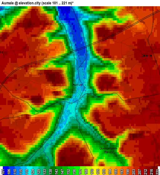
Below is the Elevation map of Aumale, which displays elevation range with different colors. Scale of the first map is from 101 to 221 m (331 to 725 ft) with average elevation of 181.6 meters (=596 ft) [note 1]
These maps also provides idea of topography and contour of this city, they are displayed at different zoom levels. More info about maps, scale and edge coordinates you can find below images.
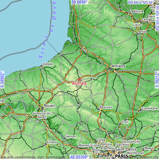
| \ | Map #1 | Topo.Map |
| Scale [m] | 101..221 m | × |
| Scale [ft] | 331..725 ft | × |
| Average | 181.6 m = 596 ft | × |
| Width | 6.31 km = 3.9 mi | 202 km = 125.5 mi |
| Height | 6.31 km = 3.9 mi | 202 km = 125.5 mi |
| ↑Max Latitude | 49.798224° | 50.6696° |
| Latitude at center | 49.76985° | 49.76985° |
| ↓Min Latitude | 49.741459° | 48.85309° |
| ← Min Longitude | 1.711925° | 0.34962° |
| Longitude center | 1.75587° | 1.75587° |
| →Max Longitude | 1.799815° | 3.16212° |
Nearby cities:
Cities around Aumale sort by population:
• Blangy-sur-Bresle elevation 47 m
20.3 km,  332°
332°
• Grandvilliers 196 m
17.7 km,  131°
131°
• Poix-de-Picardie 174 m
16.4 km,  84°
84°
• Formerie 226 m
13.5 km,  187°
187°
• Feuquières 195 m
15.2 km,  154°
154°
• Gaillefontaine 170 m
16.4 km,  218°
218°
• Hornoy-le-Bourg 165 m
13.7 km,  49°
49°
• Beaucamps-le-Vieux 186 m
8.7 km,  12°
12°
• Oisemont 122 m
20.7 km,  2°
2°
• Foucarmont 127 m
15.9 km,  302°
302°
• Bouttencourt 74 m
20.6 km, 334°
• Serqueux 167 m
21.8 km,  225°
225°
Multilingual:
 En español:
Aumale elevación 118 m.
 En France:
Aumale élévation 118 m.


Sources and notes:
- [note 1] Map square and city borders are not equal. Map elevation data is calculated only from area inside that square.
- [src 1] Elevation data from geonames database provided with same terms of usage.
- [src 2] The elevation map of Aumale is generated using elevation data from NASA's 3 arcsec (90m) resolution SRTM data.
- [src 3] Base (background) map © OpenStreetMap contributors tiles are generated by Geofabrik and OpenTopoMap.
Copyright & License:
This Aumale Elevation Map is licensed under CC BY-SA. You may reuse any part from this page, if you give a proper credit by linking to this URL:
 More info on terms of use page.