Poix-de-Picardie elevation
Poix-de-Picardie (Hauts-de-France, Somme), France elevation is 174 meters and Poix-de-Picardie elevation in feet is 571 ft above sea level [src 1]. Poix-de-Picardie is a populated place (feature code) with elevation that is 0 meters (0 ft) bigger than average city elevation in France.
Below is the Elevation map of Poix-de-Picardie, which displays elevation range with different colors. Scale of the first map is from 81 to 199 m (266 to 653 ft) with average elevation of 159.5 meters (=523 ft) [note 1]
These maps also provides idea of topography and contour of this city, they are displayed at different zoom levels. More info about maps, scale and edge coordinates you can find below images.
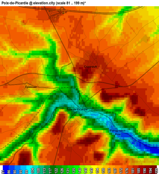
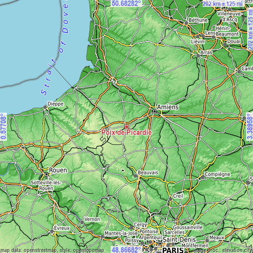
| \ | Map #1 | Topo.Map |
| Scale [m] | 81..199 m | × |
| Scale [ft] | 266..653 ft | × |
| Average | 159.5 m = 523 ft | × |
| Width | 6.31 km = 3.9 mi | 201.9 km = 125.5 mi |
| Height | 6.31 km = 3.9 mi | 201.9 km = 125.5 mi |
| ↑Max Latitude | 49.811696° | 50.68282° |
| Latitude at center | 49.78333° | 49.78333° |
| ↓Min Latitude | 49.754947° | 48.86682° |
| ← Min Longitude | 1.939385° | 0.57708° |
| Longitude center | 1.98333° | 1.98333° |
| →Max Longitude | 2.027275° | 3.38958° |
Nearby cities:
Cities around Poix-de-Picardie sort by population:
• Salouël elevation 30 m
21 km,  62°
62°
• Grandvilliers 196 m
13.5 km,  193°
193°
• Aumale 118 m
16.4 km,  264°
264°
• Saleux 33 m
19.9 km,  65°
65°
• Airaines 24 m
20.8 km,  351°
351°
• Conty 63 m
12.9 km,  111°
111°
• Pont-de-Metz 29 m
21.4 km, 60°
• Feuquières 195 m
18 km,  212°
212°
• Hornoy-le-Bourg 165 m
9.5 km,  321°
321°
• Beaucamps-le-Vieux 186 m
16 km,  295°
295°
• Picquigny 19 m
21.3 km,  32°
32°
• Quevauvillers 135 m
8.5 km, 58°
Multilingual:
 En español:
Poix-de-Picardie elevación 174 m.
 En France:
Poix-de-Picardie élévation 174 m.
 Auf Deutsch:
Poix-de-Picardie höhe über dem Meeresspiegel ist 174 m.

Sources and notes:
- [note 1] Map square and city borders are not equal. Map elevation data is calculated only from area inside that square.
- [src 1] Elevation data from geonames database provided with same terms of usage.
- [src 2] The elevation map of Poix-de-Picardie is generated using elevation data from NASA's 3 arcsec (90m) resolution SRTM data.
- [src 3] Base (background) map © OpenStreetMap contributors tiles are generated by Geofabrik and OpenTopoMap.
Copyright & License:
This Poix-de-Picardie Elevation Map is licensed under CC BY-SA. You may reuse any part from this page, if you give a proper credit by linking to this URL:
 More info on terms of use page.