Bellegarde-sur-Valserine elevation
Bellegarde-sur-Valserine (Auvergne-Rhône-Alpes, Département de l'Ain), France elevation is 361 meters and Bellegarde-sur-Valserine elevation in feet is 1184 ft above sea level [src 1]. Bellegarde-sur-Valserine is a populated place (feature code) with elevation that is 187 meters (614 ft) bigger than average city elevation in France.
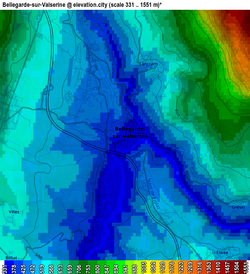
Below is the Elevation map of Bellegarde-sur-Valserine, which displays elevation range with different colors. Scale of the first map is from 331 to 1551 m (1086 to 5089 ft) with average elevation of 537.6 meters (=1764 ft) [note 1]
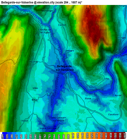
These maps also provides idea of topography and contour of this city, they are displayed at different zoom levels. More info about maps, scale and edge coordinates you can find below images.
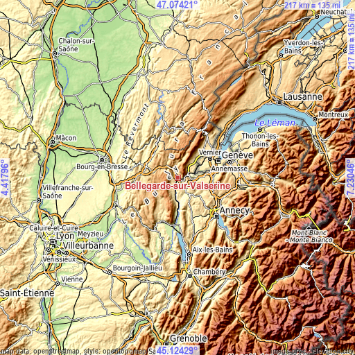
| \ | Map #1 | Map #2 | Topo.Map |
| Scale [m] | 331..1551 m | 284..1607 m | × |
| Scale [ft] | 1086..5089 ft | 932..5272 ft | × |
| Average | 537.6 m = 1764 ft | 678.2 m = 2225 ft | × |
| Width | 6.78 km = 4.2 mi | 13.55 km = 8.4 mi | 216.8 km = 134.7 mi |
| Height | 6.78 km = 4.2 mi | 13.55 km = 8.4 mi | 216.8 km = 134.7 mi |
| ↑Max Latitude | 46.138329° | 46.168771° | 47.07421° |
| Latitude at center | 46.10787° | 46.10787° | 46.10787° |
| ↓Min Latitude | 46.077394° | 46.046901° | 45.12429° |
| ← Min Longitude | 5.780265° | 5.736319° | 4.41796° |
| Longitude center | 5.82421° | 5.82421° | 5.82421° |
| →Max Longitude | 5.868155° | 5.912101° | 7.23046° |
Nearby cities:
Cities around Bellegarde-sur-Valserine sort by population:
• Thoiry elevation 489 m
18.8 km,  39°
39°
• Nantua 593 m
17.6 km,  286°
286°
• Viry 535 m
16.5 km,  88°
88°
• Châtillon-en-Michaille 537 m
4.4 km,  334°
334°
• Valleiry 469 m
11.3 km, 88°
• Frangy 379 m
12.8 km,  139°
139°
• Péron 542 m
12 km, 40°
• Saint-Jean-de-Gonville 522 m
15.2 km, 39°
• Challex 508 m
14.5 km,  53°
53°
• Collonges 450 m
7.1 km,  61°
61°
• Chilly 470 m
16.4 km, 142°
• Lancrans 503 m
2.3 km,  16°
16°
Multilingual:
 En español:
Bellegarde-sur-Valserine elevación 361 m.
 En France:
Bellegarde-sur-Valserine élévation 361 m.
 Auf Deutsch:
Bellegarde-sur-Valserine höhe über dem Meeresspiegel ist 361 m.
 На русском:
Бельгард-сюр-Вальсерин высота над уровнем моря 361 м
Sources and notes:
- [note 1] Map square and city borders are not equal. Map elevation data is calculated only from area inside that square.
- [src 1] Elevation data from geonames database provided with same terms of usage.
- [src 2] The elevation map of Bellegarde-sur-Valserine is generated using elevation data from NASA's 3 arcsec (90m) resolution SRTM data.
- [src 3] Base (background) map © OpenStreetMap contributors tiles are generated by Geofabrik and OpenTopoMap.
Copyright & License:
This Bellegarde-sur-Valserine Elevation Map is licensed under CC BY-SA. You may reuse any part from this page, if you give a proper credit by linking to this URL:
 More info on terms of use page.