Châtillon-en-Michaille elevation
Châtillon-en-Michaille (Auvergne-Rhône-Alpes, Département de l'Ain), France elevation is 537 meters and Châtillon-en-Michaille elevation in feet is 1762 ft above sea level [src 1]. Châtillon-en-Michaille is a populated place (feature code) with elevation that is 363 meters (1191 ft) bigger than average city elevation in France.
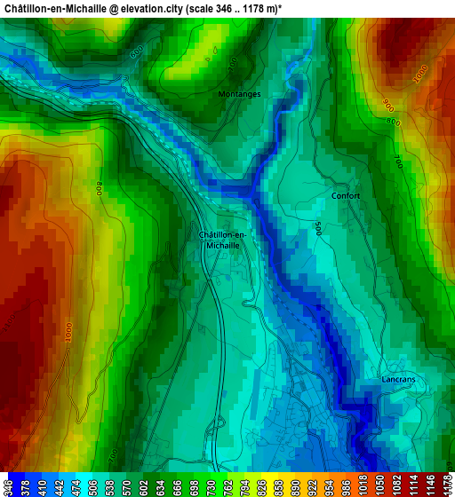
Below is the Elevation map of Châtillon-en-Michaille, which displays elevation range with different colors. Scale of the first map is from 346 to 1178 m (1135 to 3865 ft) with average elevation of 661.3 meters (=2170 ft) [note 1]
These maps also provides idea of topography and contour of this city, they are displayed at different zoom levels. More info about maps, scale and edge coordinates you can find below images.
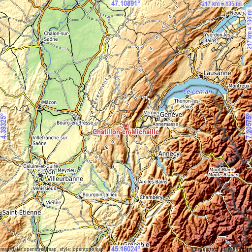
| \ | Map #1 | Topo.Map |
| Scale [m] | 346..1178 m | × |
| Scale [ft] | 1135..3865 ft | × |
| Average | 661.3 m = 2170 ft | × |
| Width | 6.77 km = 4.2 mi | 216.7 km = 134.7 mi |
| Height | 6.77 km = 4.2 mi | 216.7 km = 134.7 mi |
| ↑Max Latitude | 46.173639° | 47.10891° |
| Latitude at center | 46.1432° | 46.1432° |
| ↓Min Latitude | 46.112744° | 45.16024° |
| ← Min Longitude | 5.755555° | 4.39325° |
| Longitude center | 5.7995° | 5.7995° |
| →Max Longitude | 5.843445° | 7.20575° |
Nearby cities:
Cities around Châtillon-en-Michaille sort by population:
• Oyonnax elevation 556 m
16.9 km,  319°
319°
• Bellegarde-sur-Valserine 361 m
4.4 km,  154°
154°
• Nantua 593 m
14.9 km,  274°
274°
• Montréal-la-Cluse 515 m
17.2 km,  285°
285°
• Valleiry 469 m
13.6 km,  105°
105°
• Frangy 379 m
17.1 km,  143°
143°
• Péron 542 m
11 km,  61°
61°
• Martignat 518 m
16.3 km,  296°
296°
• Saint-Jean-de-Gonville 522 m
14 km, 56°
• Challex 508 m
14.4 km,  71°
71°
• Collonges 450 m
8.2 km,  93°
93°
• Lancrans 503 m
3.1 km,  124°
124°
Multilingual:
 En español:
Chatillon en Michaille elevación 537 m.
 En France:
Châtillon-en-Michaille élévation 537 m.
 Auf Deutsch:
Châtillon-en-Michaille höhe über dem Meeresspiegel ist 537 m.

Sources and notes:
- [note 1] Map square and city borders are not equal. Map elevation data is calculated only from area inside that square.
- [src 1] Elevation data from geonames database provided with same terms of usage.
- [src 2] The elevation map of Châtillon-en-Michaille is generated using elevation data from NASA's 3 arcsec (90m) resolution SRTM data.
- [src 3] Base (background) map © OpenStreetMap contributors tiles are generated by Geofabrik and OpenTopoMap.
Copyright & License:
This Châtillon-en-Michaille Elevation Map is licensed under CC BY-SA. You may reuse any part from this page, if you give a proper credit by linking to this URL:
 More info on terms of use page.