Nantua elevation
Nantua (Auvergne-Rhône-Alpes, Département de l'Ain), France elevation is 593 meters and Nantua elevation in feet is 1946 ft above sea level [src 1]. Nantua is a seat of a third-order administrative division (feature code) with elevation that is 419 meters (1375 ft) bigger than average city elevation in France.
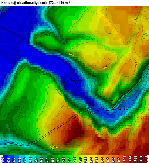
Below is the Elevation map of Nantua, which displays elevation range with different colors. Scale of the first map is from 472 to 1119 m (1549 to 3671 ft) with average elevation of 746.1 meters (=2448 ft) [note 1]
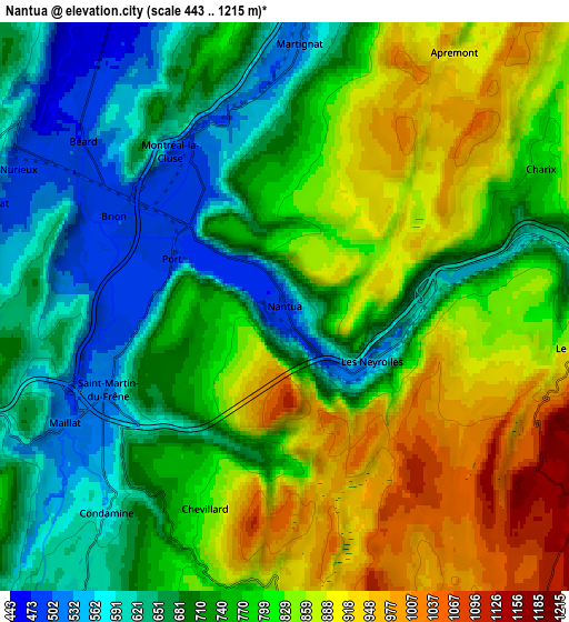
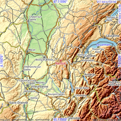
These maps also provides idea of topography and contour of this city, they are displayed at different zoom levels. More info about maps, scale and edge coordinates you can find below images.
| \ | Map #1 | Map #2 | Topo.Map |
| Scale [m] | 472..1119 m | 443..1215 m | × |
| Scale [ft] | 1549..3671 ft | 1453..3986 ft | × |
| Average | 746.1 m = 2448 ft | 764 m = 2507 ft | × |
| Width | 6.77 km = 4.2 mi | 13.54 km = 8.4 mi | 216.6 km = 134.6 mi |
| Height | 6.77 km = 4.2 mi | 13.54 km = 8.4 mi | 216.6 km = 134.6 mi |
| ↑Max Latitude | 46.183864° | 46.214281° | 47.11896° |
| Latitude at center | 46.15343° | 46.15343° | 46.15343° |
| ↓Min Latitude | 46.122979° | 46.092512° | 45.17065° |
| ← Min Longitude | 5.562065° | 5.518119° | 4.19976° |
| Longitude center | 5.60601° | 5.60601° | 5.60601° |
| →Max Longitude | 5.649955° | 5.693901° | 7.01226° |
Nearby cities:
Cities around Nantua sort by population:
• Oyonnax elevation 556 m
12.4 km,  18°
18°
• Bellegarde-sur-Valserine 361 m
17.6 km,  106°
106°
• Bellignat 528 m
10 km,  9°
9°
• Montréal-la-Cluse 515 m
3.8 km,  332°
332°
• Arbent 579 m
16.4 km, 19°
• Châtillon-en-Michaille 537 m
14.9 km,  94°
94°
• Izernore 470 m
7.9 km, 328°
• Poncin 336 m
16.8 km,  243°
243°
• Martignat 518 m
6.3 km,  3°
3°
• Villereversure 295 m
17.6 km,  281°
281°
• Saint-Martin-du-Frêne 675 m
4.7 km,  245°
245°
• Groissiat 566 m
7.6 km, 1°
Multilingual:
 En español:
Nantua elevación 593 m.
 En France:
Nantua élévation 593 m.


Sources and notes:
- [note 1] Map square and city borders are not equal. Map elevation data is calculated only from area inside that square.
- [src 1] Elevation data from geonames database provided with same terms of usage.
- [src 2] The elevation map of Nantua is generated using elevation data from NASA's 3 arcsec (90m) resolution SRTM data.
- [src 3] Base (background) map © OpenStreetMap contributors tiles are generated by Geofabrik and OpenTopoMap.
Copyright & License:
This Nantua Elevation Map is licensed under CC BY-SA. You may reuse any part from this page, if you give a proper credit by linking to this URL:
 More info on terms of use page.