Cany-Barville elevation
Cany-Barville (Normandy, Seine-Maritime), France elevation is 17 meters and Cany-Barville elevation in feet is 56 ft above sea level [src 1]. Cany-Barville is a populated place (feature code) with elevation that is 157 meters (515 ft) smaller than average city elevation in France.
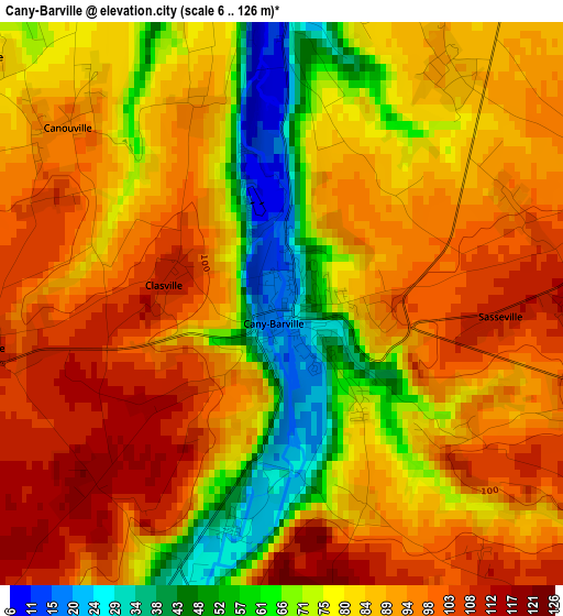
Below is the Elevation map of Cany-Barville, which displays elevation range with different colors. Scale of the first map is from 6 to 126 m (20 to 413 ft) with average elevation of 84.6 meters (=278 ft) [note 1]
These maps also provides idea of topography and contour of this city, they are displayed at different zoom levels. More info about maps, scale and edge coordinates you can find below images.
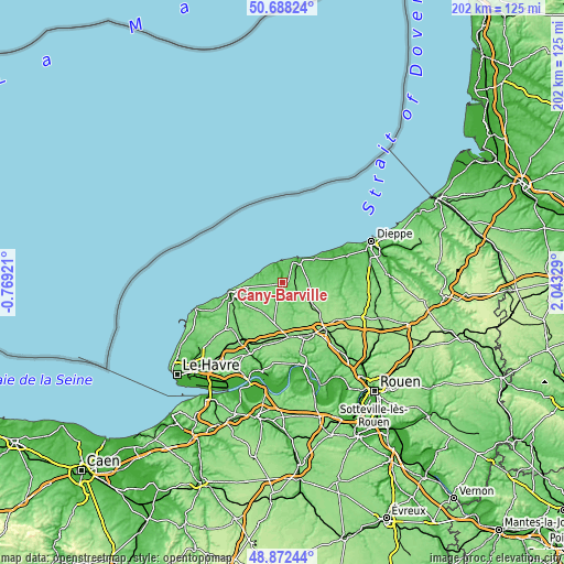
| \ | Map #1 | Topo.Map |
| Scale [m] | 6..126 m | × |
| Scale [ft] | 20..413 ft | × |
| Average | 84.6 m = 278 ft | × |
| Width | 6.31 km = 3.9 mi | 201.9 km = 125.5 mi |
| Height | 6.31 km = 3.9 mi | 201.9 km = 125.5 mi |
| ↑Max Latitude | 49.817213° | 50.68824° |
| Latitude at center | 49.78885° | 49.78885° |
| ↓Min Latitude | 49.76047° | 48.87244° |
| ← Min Longitude | 0.593095° | -0.76921° |
| Longitude center | 0.63704° | 0.63704° |
| →Max Longitude | 0.680985° | 2.04329° |
Nearby cities:
Cities around Cany-Barville sort by population:
• Fécamp elevation 17 m
19.2 km,  259°
259°
• Saint-Valery-en-Caux 68 m
11.1 km,  38°
38°
• Doudeville 122 m
12.9 km,  124°
124°
• Luneray 76 m
20.5 km,  77°
77°
• Fauville-en-Caux 129 m
15.5 km,  192°
192°
• Saint-Léonard 97 m
20.6 km, 255°
• Yébleron 143 m
18.7 km,  202°
202°
• Valliquerville 131 m
19.8 km,  169°
169°
• Néville 71 m
6.5 km,  52°
52°
• Grainville-la-Teinturière 37 m
4.6 km,  176°
176°
• Ourville-en-Caux 118 m
7.1 km, 199°
• Fontaine-le-Dun 53 m
15.6 km, 80°
Multilingual:
 En español:
Cany-Barville elevación 17 m.
 En France:
Cany-Barville élévation 17 m.
 Auf Deutsch:
Cany-Barville höhe über dem Meeresspiegel ist 17 m.

Sources and notes:
- [note 1] Map square and city borders are not equal. Map elevation data is calculated only from area inside that square.
- [src 1] Elevation data from geonames database provided with same terms of usage.
- [src 2] The elevation map of Cany-Barville is generated using elevation data from NASA's 3 arcsec (90m) resolution SRTM data.
- [src 3] Base (background) map © OpenStreetMap contributors tiles are generated by Geofabrik and OpenTopoMap.
Copyright & License:
This Cany-Barville Elevation Map is licensed under CC BY-SA. You may reuse any part from this page, if you give a proper credit by linking to this URL:
 More info on terms of use page.