Yébleron elevation
Yébleron (Normandy, Seine-Maritime), France elevation is 143 meters and Yébleron elevation in feet is 469 ft above sea level [src 1]. Yébleron is a populated place (feature code) with elevation that is 31 meters (102 ft) smaller than average city elevation in France.
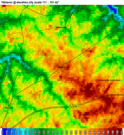
Below is the Elevation map of Yébleron, which displays elevation range with different colors. Scale of the first map is from 111 to 151 m (364 to 495 ft) with average elevation of 134 meters (=440 ft) [note 1]
These maps also provides idea of topography and contour of this city, they are displayed at different zoom levels. More info about maps, scale and edge coordinates you can find below images.
| \ | Map #1 | Topo.Map |
| Scale [m] | 111..151 m | × |
| Scale [ft] | 364..495 ft | × |
| Average | 134 m = 440 ft | × |
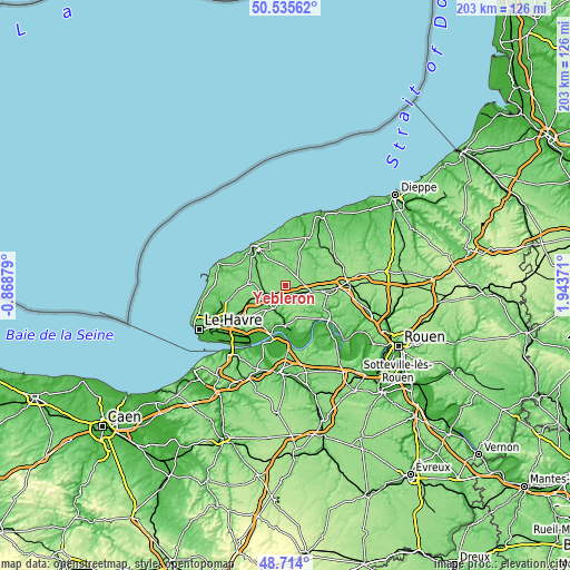
| Width | 6.33 km = 3.9 mi | 202.5 km = 125.8 mi |
| Height | 6.33 km = 3.9 mi | 202.5 km = 125.8 mi |
| ↑Max Latitude | 49.661784° | 50.53562° |
| Latitude at center | 49.63333° | 49.63333° |
| ↓Min Latitude | 49.604859° | 48.714° |
| ← Min Longitude | 0.493515° | -0.86879° |
| Longitude center | 0.53746° | 0.53746° |
| →Max Longitude | 0.581405° | 1.94371° |
Nearby cities:
Cities around Yébleron sort by population:
• Bolbec elevation 54 m
8.1 km,  214°
214°
• Gruchet-le-Valasse 26 m
9.5 km,  202°
202°
• Goderville 126 m
12.4 km,  276°
276°
• Fauville-en-Caux 129 m
4.5 km,  61°
61°
• Bretteville-du-Grand-Caux 97 m
10.6 km,  290°
290°
• Saint-Eustache-la-Forêt 105 m
10.8 km, 212°
• Valliquerville 131 m
11 km,  101°
101°
• Bréauté 116 m
9.9 km,  266°
266°
• Nointot 140 m
5.9 km,  228°
228°
• Beuzeville-la-Grenier 118 m
9.2 km,  239°
239°
• Ourville-en-Caux 118 m
11.6 km,  24°
24°
• Lanquetot 142 m
5.4 km,  188°
188°
Multilingual:
 En español:
Yébleron elevación 143 m.
 En France:
Yébleron élévation 143 m.
 Auf Deutsch:
Yébleron höhe über dem Meeresspiegel ist 143 m.

Sources and notes:
- [note 1] Map square and city borders are not equal. Map elevation data is calculated only from area inside that square.
- [src 1] Elevation data from geonames database provided with same terms of usage.
- [src 2] The elevation map of Yébleron is generated using elevation data from NASA's 3 arcsec (90m) resolution SRTM data.
- [src 3] Base (background) map © OpenStreetMap contributors tiles are generated by Geofabrik and OpenTopoMap.
Copyright & License:
This Yébleron Elevation Map is licensed under CC BY-SA. You may reuse any part from this page, if you give a proper credit by linking to this URL:
 More info on terms of use page.