Nointot elevation
Nointot (Normandy, Seine-Maritime), France elevation is 140 meters and Nointot elevation in feet is 459 ft above sea level [src 1]. Nointot is a populated place (feature code) with elevation that is 34 meters (112 ft) smaller than average city elevation in France.
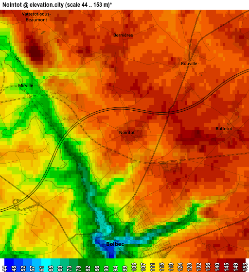
Below is the Elevation map of Nointot, which displays elevation range with different colors. Scale of the first map is from 44 to 153 m (144 to 502 ft) with average elevation of 121.6 meters (=399 ft) [note 1]
These maps also provides idea of topography and contour of this city, they are displayed at different zoom levels. More info about maps, scale and edge coordinates you can find below images.
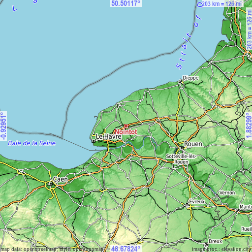
| \ | Map #1 | Topo.Map |
| Scale [m] | 44..153 m | × |
| Scale [ft] | 144..502 ft | × |
| Average | 121.6 m = 399 ft | × |
| Width | 6.33 km = 3.9 mi | 202.7 km = 126 mi |
| Height | 6.33 km = 3.9 mi | 202.7 km = 126 mi |
| ↑Max Latitude | 49.626695° | 50.50117° |
| Latitude at center | 49.59822° | 49.59822° |
| ↓Min Latitude | 49.569729° | 48.67824° |
| ← Min Longitude | 0.432795° | -0.92951° |
| Longitude center | 0.47674° | 0.47674° |
| →Max Longitude | 0.520685° | 1.88299° |
Nearby cities:
Cities around Nointot sort by population:
• Bolbec elevation 54 m
2.8 km,  184°
184°
• Lillebonne 15 m
9.7 km,  153°
153°
• Gruchet-le-Valasse 26 m
4.9 km,  171°
171°
• Goderville 126 m
9.6 km,  303°
303°
• Yébleron 143 m
5.9 km,  48°
48°
• Bretteville-du-Grand-Caux 97 m
9.4 km,  324°
324°
• Saint-Eustache-la-Forêt 105 m
5.4 km,  196°
196°
• La Remuée 127 m
9.5 km,  214°
214°
• Bréauté 116 m
6.4 km, 300°
• Saint-Nicolas-de-la-Taille 109 m
9.7 km, 181°
• Beuzeville-la-Grenier 118 m
3.7 km,  258°
258°
• Lanquetot 142 m
3.9 km,  111°
111°
Multilingual:
 En español:
Nointot elevación 140 m.
 En France:
Nointot élévation 140 m.


Sources and notes:
- [note 1] Map square and city borders are not equal. Map elevation data is calculated only from area inside that square.
- [src 1] Elevation data from geonames database provided with same terms of usage.
- [src 2] The elevation map of Nointot is generated using elevation data from NASA's 3 arcsec (90m) resolution SRTM data.
- [src 3] Base (background) map © OpenStreetMap contributors tiles are generated by Geofabrik and OpenTopoMap.
Copyright & License:
This Nointot Elevation Map is licensed under CC BY-SA. You may reuse any part from this page, if you give a proper credit by linking to this URL:
 More info on terms of use page.