Clamecy elevation
Clamecy (Bourgogne-Franche-Comté, Département de la Nièvre), France elevation is 190 meters and Clamecy elevation in feet is 623 ft above sea level [src 1]. Clamecy is a seat of a third-order administrative division (feature code) with elevation that is 16 meters (52 ft) bigger than average city elevation in France.
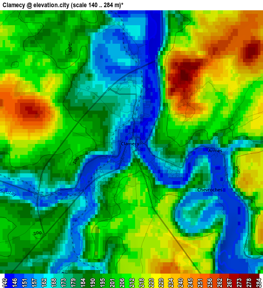
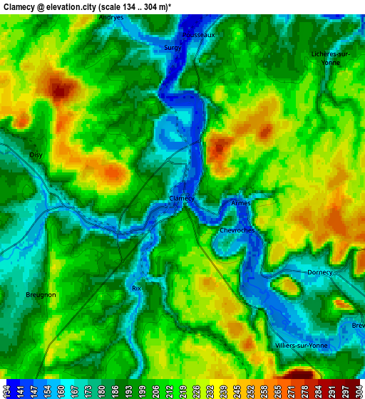
Below is the Elevation map of Clamecy, which displays elevation range with different colors. Scale of the first map is from 140 to 284 m (459 to 932 ft) with average elevation of 194.9 meters (=639 ft) [note 1]
These maps also provides idea of topography and contour of this city, they are displayed at different zoom levels. More info about maps, scale and edge coordinates you can find below images.
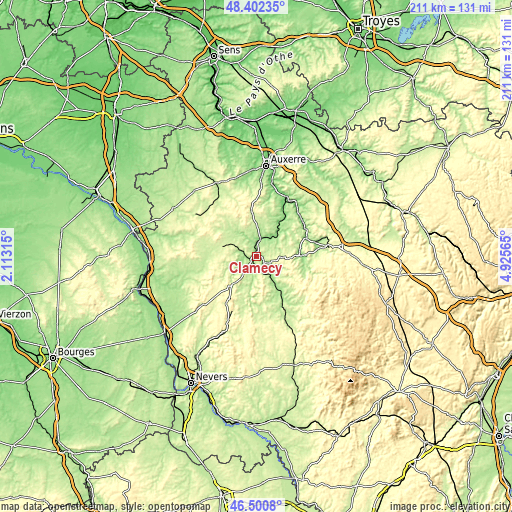
| \ | Map #1 | Map #2 | Topo.Map |
| Scale [m] | 140..284 m | 134..304 m | × |
| Scale [ft] | 459..932 ft | 440..997 ft | × |
| Average | 194.9 m = 639 ft | 201.5 m = 661 ft | × |
| Width | 6.61 km = 4.1 mi | 13.21 km = 8.2 mi | 211.4 km = 131.4 mi |
| Height | 6.61 km = 4.1 mi | 13.21 km = 8.2 mi | 211.4 km = 131.4 mi |
| ↑Max Latitude | 47.489873° | 47.519559° | 48.40235° |
| Latitude at center | 47.46017° | 47.46017° | 47.46017° |
| ↓Min Latitude | 47.43045° | 47.400713° | 46.5008° |
| ← Min Longitude | 3.475455° | 3.431509° | 2.11315° |
| Longitude center | 3.5194° | 3.5194° | 3.5194° |
| →Max Longitude | 3.563345° | 3.607291° | 4.92565° |
Nearby cities:
Cities around Clamecy sort by population:
• Avallon elevation 246 m
29.4 km,  83°
83°
• Corbigny 200 m
25.7 km,  151°
151°
• Donzy 180 m
31.3 km,  251°
251°
• Champs-sur-Yonne 102 m
31 km,  11°
11°
• Varzy 222 m
15.1 km,  221°
221°
• Saint-Amand-en-Puisaye 187 m
34.3 km,  282°
282°
• Lormes 424 m
29.4 km,  130°
130°
• Pourrain 261 m
33.9 km,  346°
346°
• Vermenton 129 m
27.9 km,  35°
35°
• Joux-la-Ville 227 m
31.4 km,  54°
54°
• Diges 219 m
31.2 km,  343°
343°
• Saint-Bris-le-Vineux 168 m
33 km,  17°
17°
Multilingual:
 En español:
Clamecy elevación 190 m.
 En France:
Clamecy élévation 190 m.


Sources and notes:
- [note 1] Map square and city borders are not equal. Map elevation data is calculated only from area inside that square.
- [src 1] Elevation data from geonames database provided with same terms of usage.
- [src 2] The elevation map of Clamecy is generated using elevation data from NASA's 3 arcsec (90m) resolution SRTM data.
- [src 3] Base (background) map © OpenStreetMap contributors tiles are generated by Geofabrik and OpenTopoMap.
Copyright & License:
This Clamecy Elevation Map is licensed under CC BY-SA. You may reuse any part from this page, if you give a proper credit by linking to this URL:
 More info on terms of use page.