Saint-Amand-en-Puisaye elevation
Saint-Amand-en-Puisaye (Bourgogne-Franche-Comté, Département de la Nièvre), France elevation is 187 meters and Saint-Amand-en-Puisaye elevation in feet is 614 ft above sea level [src 1]. Saint-Amand-en-Puisaye is a populated place (feature code) with elevation that is 13 meters (43 ft) bigger than average city elevation in France.
Below is the Elevation map of Saint-Amand-en-Puisaye, which displays elevation range with different colors. Scale of the first map is from 164 to 288 m (538 to 945 ft) with average elevation of 219.8 meters (=721 ft) [note 1]
These maps also provides idea of topography and contour of this city, they are displayed at different zoom levels. More info about maps, scale and edge coordinates you can find below images.
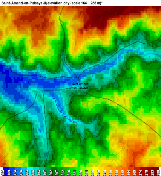
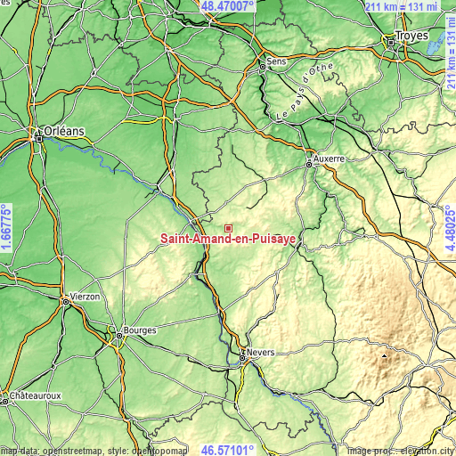
| \ | Map #1 | Topo.Map |
| Scale [m] | 164..288 m | × |
| Scale [ft] | 538..945 ft | × |
| Average | 219.8 m = 721 ft | × |
| Width | 6.6 km = 4.1 mi | 211.2 km = 131.2 mi |
| Height | 6.6 km = 4.1 mi | 211.1 km = 131.2 mi |
| ↑Max Latitude | 47.558794° | 48.47007° |
| Latitude at center | 47.52913° | 47.52913° |
| ↓Min Latitude | 47.499449° | 46.57101° |
| ← Min Longitude | 3.030055° | 1.66775° |
| Longitude center | 3.074° | 3.074° |
| →Max Longitude | 3.117945° | 4.48025° |
Nearby cities:
Cities around Saint-Amand-en-Puisaye sort by population:
• Cosne-Cours-sur-Loire elevation 149 m
17.2 km,  220°
220°
• Briare 140 m
27.3 km,  295°
295°
• Bonny-sur-Loire 139 m
18 km,  281°
281°
• Donzy 180 m
18 km,  167°
167°
• Saint-Fargeau 189 m
12.5 km,  358°
358°
• Bléneau 166 m
21.2 km,  333°
333°
• Boulleret 170 m
19.1 km,  232°
232°
• Neuvy-sur-Loire 139 m
14.3 km,  267°
267°
• Léré 153 m
16.7 km,  246°
246°
• Ouzouer-sur-Trézée 161 m
25.5 km,  308°
308°
• Belleville-sur-Loire 141 m
17.1 km,  259°
259°
• Savigny-en-Sancerre 215 m
22.1 km,  243°
243°
Multilingual:
 En español:
Saint-Amand-en-Puisaye elevación 187 m.
 En France:
Saint-Amand-en-Puisaye élévation 187 m.
 Auf Deutsch:
Saint-Amand-en-Puisaye höhe über dem Meeresspiegel ist 187 m.
 На русском:
Saint-Amand-en-Puisaye высота над уровнем моря 187 м
Sources and notes:
- [note 1] Map square and city borders are not equal. Map elevation data is calculated only from area inside that square.
- [src 1] Elevation data from geonames database provided with same terms of usage.
- [src 2] The elevation map of Saint-Amand-en-Puisaye is generated using elevation data from NASA's 3 arcsec (90m) resolution SRTM data.
- [src 3] Base (background) map © OpenStreetMap contributors tiles are generated by Geofabrik and OpenTopoMap.
Copyright & License:
This Saint-Amand-en-Puisaye Elevation Map is licensed under CC BY-SA. You may reuse any part from this page, if you give a proper credit by linking to this URL:
 More info on terms of use page.