Léré elevation
Léré (Centre, Cher), France elevation is 153 meters and Léré elevation in feet is 502 ft above sea level [src 1]. Léré is a populated place (feature code) with elevation that is 21 meters (69 ft) smaller than average city elevation in France.
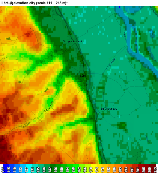
Below is the Elevation map of Léré, which displays elevation range with different colors. Scale of the first map is from 111 to 213 m (364 to 699 ft) with average elevation of 157 meters (=515 ft) [note 1]
These maps also provides idea of topography and contour of this city, they are displayed at different zoom levels. More info about maps, scale and edge coordinates you can find below images.
| \ | Map #1 | Topo.Map |
| Scale [m] | 111..213 m | × |
| Scale [ft] | 364..699 ft | × |
| Average | 157 m = 515 ft | × |
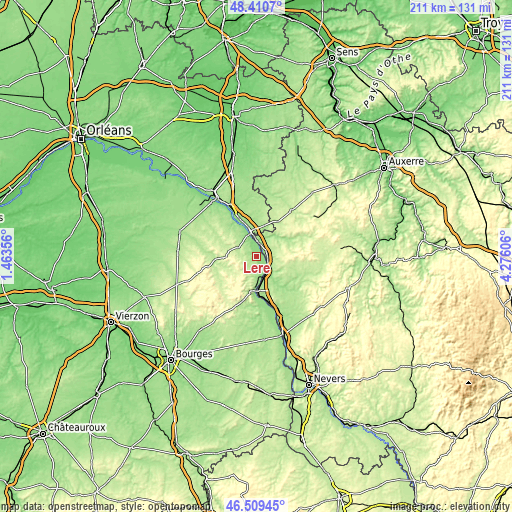
| Width | 6.61 km = 4.1 mi | 211.4 km = 131.4 mi |
| Height | 6.61 km = 4.1 mi | 211.4 km = 131.4 mi |
| ↑Max Latitude | 47.498368° | 48.4107° |
| Latitude at center | 47.46867° | 47.46867° |
| ↓Min Latitude | 47.438955° | 46.50945° |
| ← Min Longitude | 2.825865° | 1.46356° |
| Longitude center | 2.86981° | 2.86981° |
| →Max Longitude | 2.913755° | 4.27606° |
Nearby cities:
Cities around Léré sort by population:
• Cosne-Cours-sur-Loire elevation 149 m
7.6 km,  146°
146°
• Briare 140 m
20.6 km,  332°
332°
• Bonny-sur-Loire 139 m
10.6 km,  347°
347°
• Sancerre 252 m
15.8 km,  189°
189°
• Saint-Satur 165 m
14.6 km, 189°
• Pouilly-sur-Loire 166 m
21.5 km,  162°
162°
• Donzy 180 m
22.1 km,  119°
119°
• Boulleret 170 m
5 km,  176°
176°
• Saint-Amand-en-Puisaye 187 m
16.7 km,  66°
66°
• Neuvy-sur-Loire 139 m
6.2 km,  9°
9°
• Belleville-sur-Loire 141 m
3.8 km,  336°
336°
• Savigny-en-Sancerre 215 m
5.5 km,  236°
236°
Multilingual:
 En español:
Léré elevación 153 m.
 En France:
Léré élévation 153 m.


Sources and notes:
- [note 1] Map square and city borders are not equal. Map elevation data is calculated only from area inside that square.
- [src 1] Elevation data from geonames database provided with same terms of usage.
- [src 2] The elevation map of Léré is generated using elevation data from NASA's 3 arcsec (90m) resolution SRTM data.
- [src 3] Base (background) map © OpenStreetMap contributors tiles are generated by Geofabrik and OpenTopoMap.
Copyright & License:
This Léré Elevation Map is licensed under CC BY-SA. You may reuse any part from this page, if you give a proper credit by linking to this URL:
 More info on terms of use page.