Corbigny elevation
Corbigny (Bourgogne-Franche-Comté, Département de la Nièvre), France elevation is 200 meters and Corbigny elevation in feet is 656 ft above sea level [src 1]. Corbigny is a populated place (feature code) with elevation that is 26 meters (85 ft) bigger than average city elevation in France.
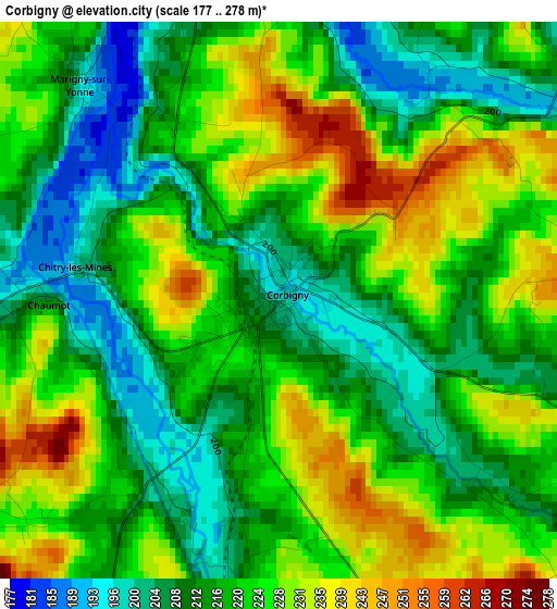
Below is the Elevation map of Corbigny, which displays elevation range with different colors. Scale of the first map is from 177 to 278 m (581 to 912 ft) with average elevation of 219.6 meters (=720 ft) [note 1]
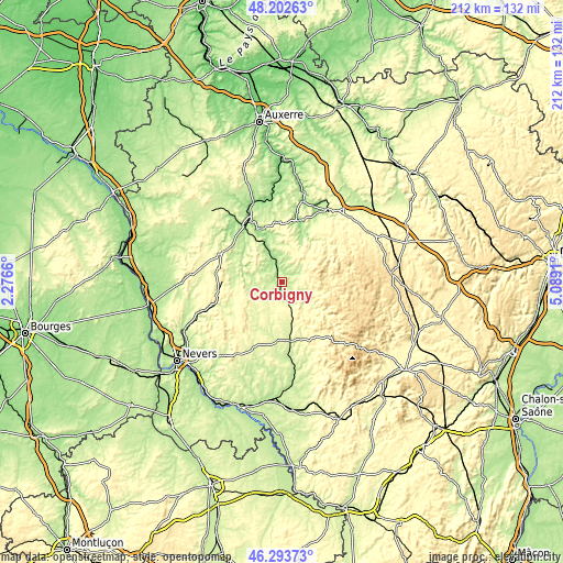
These maps also provides idea of topography and contour of this city, they are displayed at different zoom levels. More info about maps, scale and edge coordinates you can find below images.
| \ | Map #1 | Topo.Map |
| Scale [m] | 177..278 m | × |
| Scale [ft] | 581..912 ft | × |
| Average | 219.6 m = 720 ft | × |
| Width | 6.63 km = 4.1 mi | 212.2 km = 131.9 mi |
| Height | 6.63 km = 4.1 mi | 212.2 km = 131.9 mi |
| ↑Max Latitude | 47.286598° | 48.20263° |
| Latitude at center | 47.25678° | 47.25678° |
| ↓Min Latitude | 47.226945° | 46.29373° |
| ← Min Longitude | 3.638905° | 2.2766° |
| Longitude center | 3.68285° | 3.68285° |
| →Max Longitude | 3.726795° | 5.0891° |
Nearby cities:
Cities around Corbigny sort by population:
• Avallon elevation 246 m
31 km,  33°
33°
• Clamecy 190 m
25.7 km,  331°
331°
• Saulieu 537 m
41.3 km,  86°
86°
• Château-Chinon(Ville) 556 m
28.4 km,  138°
138°
• Guérigny 226 m
41 km,  242°
242°
• Prémery 233 m
28.5 km,  250°
250°
• Moulins-Engilbert 230 m
31.4 km,  162°
162°
• Varzy 222 m
25 km,  296°
296°
• Lormes 424 m
10.8 km,  70°
70°
• Saint-Benin-d’Azy 249 m
36.1 km,  217°
217°
• Joux-la-Ville 227 m
42.8 km,  18°
18°
• Châtillon-en-Bazois 238 m
22.5 km,  184°
184°
Multilingual:
 En español:
Corbigny elevación 200 m.
 En France:
Corbigny élévation 200 m.
 Auf Deutsch:
Corbigny höhe über dem Meeresspiegel ist 200 m.

Sources and notes:
- [note 1] Map square and city borders are not equal. Map elevation data is calculated only from area inside that square.
- [src 1] Elevation data from geonames database provided with same terms of usage.
- [src 2] The elevation map of Corbigny is generated using elevation data from NASA's 3 arcsec (90m) resolution SRTM data.
- [src 3] Base (background) map © OpenStreetMap contributors tiles are generated by Geofabrik and OpenTopoMap.
Copyright & License:
This Corbigny Elevation Map is licensed under CC BY-SA. You may reuse any part from this page, if you give a proper credit by linking to this URL:
 More info on terms of use page.