Dourdan elevation
Dourdan (Île-de-France, Département de l'Essonne), France elevation is 95 meters and Dourdan elevation in feet is 312 ft above sea level [src 1]. Dourdan is a populated place (feature code) with elevation that is 79 meters (259 ft) smaller than average city elevation in France.
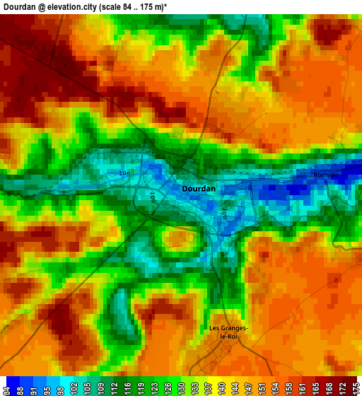
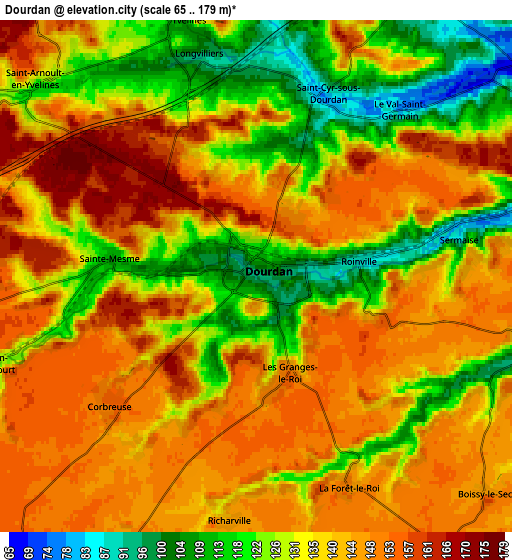
Below is the Elevation map of Dourdan, which displays elevation range with different colors. Scale of the first map is from 84 to 175 m (276 to 574 ft) with average elevation of 137.4 meters (=451 ft) [note 1]
These maps also provides idea of topography and contour of this city, they are displayed at different zoom levels. More info about maps, scale and edge coordinates you can find below images.
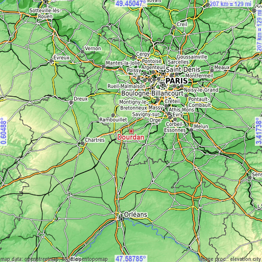
| \ | Map #1 | Map #2 | Topo.Map |
| Scale [m] | 84..175 m | 65..179 m | × |
| Scale [ft] | 276..574 ft | 213..587 ft | × |
| Average | 137.4 m = 451 ft | 137.1 m = 450 ft | × |
| Width | 6.47 km = 4 mi | 12.94 km = 8 mi | 207.1 km = 128.7 mi |
| Height | 6.47 km = 4 mi | 12.94 km = 8 mi | 207.1 km = 128.7 mi |
| ↑Max Latitude | 48.556815° | 48.585893° | 49.45047° |
| Latitude at center | 48.52772° | 48.52772° | 48.52772° |
| ↓Min Latitude | 48.498609° | 48.46948° | 47.58785° |
| ← Min Longitude | 1.967185° | 1.923239° | 0.60488° |
| Longitude center | 2.01113° | 2.01113° | 2.01113° |
| →Max Longitude | 2.055075° | 2.099021° | 3.41738° |
Nearby cities:
Cities around Dourdan sort by population:
• Saint-Arnoult-en-Yvelines elevation 118 m
7.1 km,  312°
312°
• Saint-Chéron 101 m
8.8 km,  70°
70°
• Bonnelles 121 m
10.1 km,  7°
7°
• Bullion 105 m
10.7 km,  351°
351°
• Sonchamp 139 m
11.2 km,  298°
298°
• Corbreuse 151 m
4.9 km,  231°
231°
• Le Val-Saint-Germain 76 m
5.8 km,  42°
42°
• Angervilliers 115 m
8.2 km,  28°
28°
• Saint-Maurice-Montcouronne 96 m
10.4 km,  53°
53°
• Chalo-Saint-Mars 94 m
12.3 km,  161°
161°
• Vaugrigneuse 82 m
11.7 km, 44°
• Saint-Cyr-sous-Dourdan 82 m
4.6 km,  20°
20°
Multilingual:
 En español:
Dourdan elevación 95 m.
 En France:
Dourdan élévation 95 m.


Sources and notes:
- [note 1] Map square and city borders are not equal. Map elevation data is calculated only from area inside that square.
- [src 1] Elevation data from geonames database provided with same terms of usage.
- [src 2] The elevation map of Dourdan is generated using elevation data from NASA's 3 arcsec (90m) resolution SRTM data.
- [src 3] Base (background) map © OpenStreetMap contributors tiles are generated by Geofabrik and OpenTopoMap.
Copyright & License:
This Dourdan Elevation Map is licensed under CC BY-SA. You may reuse any part from this page, if you give a proper credit by linking to this URL:
 More info on terms of use page.