Bullion elevation
Bullion (Île-de-France, Yvelines), France elevation is 105 meters and Bullion elevation in feet is 344 ft above sea level [src 1]. Bullion is a populated place (feature code) with elevation that is 69 meters (226 ft) smaller than average city elevation in France.
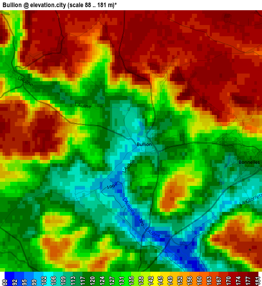
Below is the Elevation map of Bullion, which displays elevation range with different colors. Scale of the first map is from 88 to 181 m (289 to 594 ft) with average elevation of 139.6 meters (=458 ft) [note 1]
These maps also provides idea of topography and contour of this city, they are displayed at different zoom levels. More info about maps, scale and edge coordinates you can find below images.
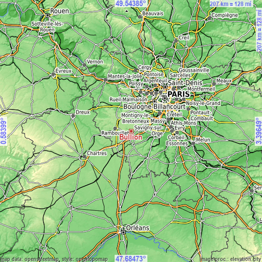
| \ | Map #1 | Topo.Map |
| Scale [m] | 88..181 m | × |
| Scale [ft] | 289..594 ft | × |
| Average | 139.6 m = 458 ft | × |
| Width | 6.46 km = 4 mi | 206.7 km = 128.4 mi |
| Height | 6.46 km = 4 mi | 206.7 km = 128.4 mi |
| ↑Max Latitude | 48.65189° | 49.54385° |
| Latitude at center | 48.62285° | 48.62285° |
| ↓Min Latitude | 48.593793° | 47.68473° |
| ← Min Longitude | 1.946295° | 0.58399° |
| Longitude center | 1.99024° | 1.99024° |
| →Max Longitude | 2.034185° | 3.39649° |
Nearby cities:
Cities around Bullion sort by population:
• Limours elevation 136 m
6.9 km,  67°
67°
• Saint-Arnoult-en-Yvelines 118 m
6.9 km,  212°
212°
• Chevreuse 92 m
9.8 km,  18°
18°
• Forges-les-Bains 117 m
8.3 km,  84°
84°
• Briis-sous-Forges 101 m
9.6 km,  89°
89°
• Bonnelles 121 m
2.9 km,  100°
100°
• Cernay-la-Ville 167 m
5.7 km,  348°
348°
• Les Molières 174 m
8.1 km,  46°
46°
• Le Val-Saint-Germain 76 m
8.4 km,  139°
139°
• Angervilliers 115 m
6.5 km,  121°
121°
• Dampierre-en-Yvelines 96 m
8.6 km,  356°
356°
• Saint-Cyr-sous-Dourdan 82 m
7 km,  153°
153°
Multilingual:
 En español:
Bullion elevación 105 m.
 En France:
Bullion élévation 105 m.


Sources and notes:
- [note 1] Map square and city borders are not equal. Map elevation data is calculated only from area inside that square.
- [src 1] Elevation data from geonames database provided with same terms of usage.
- [src 2] The elevation map of Bullion is generated using elevation data from NASA's 3 arcsec (90m) resolution SRTM data.
- [src 3] Base (background) map © OpenStreetMap contributors tiles are generated by Geofabrik and OpenTopoMap.
Copyright & License:
This Bullion Elevation Map is licensed under CC BY-SA. You may reuse any part from this page, if you give a proper credit by linking to this URL:
 More info on terms of use page.